Browse Listings in Antique Maps > Map Types > Asian Made Maps & Items
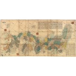
Map of the Districts and Countries of Great Japan
This is a spectacular, large format folding map of Japan by Takashiba Ei'San'Yu, dated 1849. The map presents the primary Japanese islands of Kyushu, Honshu, Shikoku and ...
Place & Date: Japan, 1849
Selling price: $800
Sold in 2023
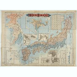
Kaisei dosen Dai Nihon yochi zenzu.
Title in top : "Dai Nihon yochi zenzu.". Showing Japan, Korea and in an inset Hokkaido. Folding copperplate print in Japanese. Relief shown by hachures. Include...
- $350 / ≈ €320.18
Place & Date: Tokyo, Meiji 10 or 1877
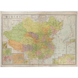
New China Map.
Very large and detailed map of China (1:6,000,000) printed in Shanghai, June 27th 1938 by JIN-SHIN GEOGRAPHICAL INSTITUTE.The title and place names in Chinese and Engli...
- $900 / ≈ €823.31
Place & Date: Shanghai, June 27th 1938