Browse Listings in Antique Maps > Asia > East Asia / Caspain Sea
![Tabula Asiae XI. [Southeast Asia]](/uploads/cache/47432-250x250.jpg)
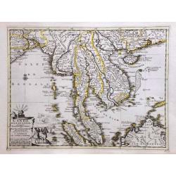
Tabula Asiae XI. [Southeast Asia]
Gastaldi's map showing Southeast Asia and the Indian Ocean based upon Ptolemy.It is one of the earliest obtainable maps of the region .From Giacomo Gastaldi's Atlas of 15...
Place & Date: Venice, 1548
Selling price: $300
Sold in 2023
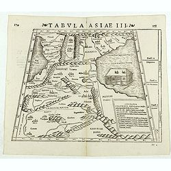
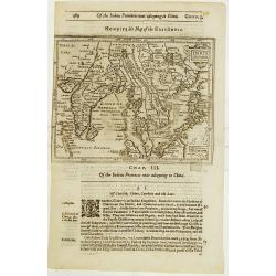
Tabula Asiae III. (Armenia)
Double-page woodcut Ptolemaic-style map by Sebastian Münster figuring Armenia, published in the edition of Strabo by Henri Petri in 1571."Strabonis rerum geographic...
Place & Date: Basle, Henri Petri, 1571
Selling price: $100
Sold in 2018
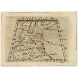
Tabula Asiae III
The ancient depiction of the region between the Black Sea and Caspian Sea extending south to include all of Armenia Maior and part of Armenia Minoris, based on Claudius P...
Place & Date: Venice, 1561-1574
Selling price: $210
Sold in 2014
Sarmatia Asie.
The map is showing the area of Armenia and Kazakhstan. From his Cosmographia, that great compendium of Renaissance knowledge. An exciting print.Sebastian Münster was bor...
Place & Date: Basle, 1550-1580
Selling price: $50
Sold in 2008
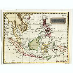
Indiae Orientalis Insularum Que Adi Acientium Tiipus.
A lovely, miniature map of south east Asia. With Latin text on verso.from an Italian edition of Ortelius Epitome atlas. Box title.
Place & Date: Venice, ca. 1590
Selling price: $190
Sold in 2020
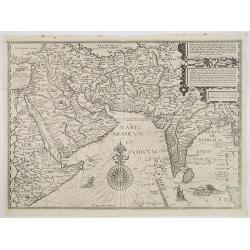
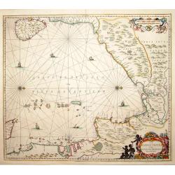
Afbeeldinge der custen van Abex, der engte van Mecha..
A highly decorative and distinctive map showing eastern Africa, Arabia, Persia and India, with rhumb lines and decorative compass roses in sea areas. A lion, elephant and...
Place & Date: Amsterdam 1596
Selling price: $1950
Sold
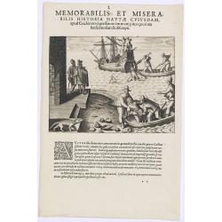
Memorabilis et Miserabilis Historia Nautae Cuiusdam.
Scene in Indochina of the first part of the voyage of van de Neck and Wybrandt van Warwijk to the East Indies.Theodore de Bry, a German engraver and book dealer, began a ...
Place & Date: Frankfurt, 1609
Selling price: $100
Sold in 2013
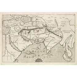
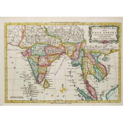
(Map of East Asia, centered on India).
Early map of the Indian Ocean region, from the Eastern Mediterranean (Alexandria) to Malaysia and Sumatra. Shows The passage of Nimrod and The passage of Ophir en Hauilah...
Place & Date: London, 1614
Selling price: $220
Sold in 2012
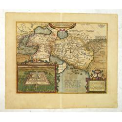
Alexandri Magni ma Cedonis Expeditio. . .
Historical map of the Near East showing the expedition of Alexandre the Great.The inset lower left shows the oracle of Jupiter Ammon, supposedly situated in present day L...
Place & Date: Antwerp, 1624
Selling price: $475
Sold in 2012
India Orientalis.
The rare Samuel Purchas' edition of the Mercator/Hondius Atlas Minor atlas map. Early map of the East Indies published in his famous collection of voyages His Pilgrimes. ...
Place & Date: London 1625
Selling price: $120
Sold

Tartaria
A rare map from "Asiae Nova Descriptio [Tabularum libri IV]", f.3, which is among the Asian part of the "Tabularum geographicarum contractarum libri quatu...
Place & Date: Amsterdam, 1649
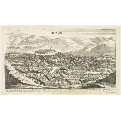
Irivan.
Bird's eye-view of Irivan in Armenia. The print has a lettered key (A-L). Engraved by I. Peeters.From ' Description des principales villes, havres et Isles du Golfe de Ve...
Place & Date: Antwerp, ca 1650
Selling price: $160
Sold in 2009
Partie de l'Inde au-delà du Gange. / Presqu'Isle de l'Inde au-delà du Gange.
Two maps together on one sheet. The first depicts north-east India from the gulf of Bengal to the border of China. The second depicts the Malaya Peninsular and Sumatra. F...
Place & Date: Paris, 1652
Selling price: $90
Sold in 2012
La Chine vaec l'Empire du Mogol. . .
Uncommon map the Far East including China, Korea, Japan, Indonesia with Philippines, etc.
Place & Date: Paris, 1676
Selling price: $3100
Sold in 2012
Sinus Gangeticus vulgo Golfo de Bengala Nova descriptio.
Showing the east coast of India and Sri Lanka. West to the top.
Place & Date: Amsterdam 1680
Selling price: $500
Sold
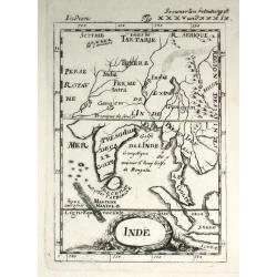
Inde
Alain Manneson Mallet (1603-1706) published in 1683 his ' Description de l' Univers' in 5 volumes. In 1686 a German edition appeared. A map from the German edition of 'De...
Place & Date: Paris, 1686
Selling price: $55
Sold
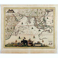
Nova Tabula Indiae Orientalis.
Covers an area from the Cape of Good Hope to Japan, including the East Indies, and Australia as discovered by Tasman lettered Nova Hollandia, Terradel Zur . An unchanged ...
Place & Date: Amsterdam, 1700
Selling price: $4000
Sold in 2023
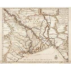
Nieuwe kaart van 't Koninckryk Bengale..
"Rare map Bangladesh with the Ganges delta, including Calcutta. Giving great detail with trade routes, European trade settlements, etc. Prepared by Joh. Van Leenen w...
Place & Date: Amsterdam 1726
Selling price: $150
Sold
L'Inde de la le Gange, suivant les nouvelles observations.
A decorative map of Malaysia, Thailand, Indo China and the Northern parts of the islands of Sumatra and Borneo. Singapore marked as Sincapour. Pieter van der Aa is highl...
Place & Date: Amsterdam, c. 1730
Selling price: $660
Sold in 2014
![[ Lot of 2 maps of the Asian continent]Asia Divisa in Imperia, Regna & Status in que distribuitur, ad usum serenissimi Burgundiae Ducis](/uploads/cache/86164-250x250.jpg)
[ Lot of 2 maps of the Asian continent]Asia Divisa in Imperia, Regna & Status in que distribuitur, ad usum serenissimi Burgundiae Ducis
Fine map of the Asian continent published in Amsterdam by R. and J. Ottens, after H. Jaillot.Together with a map by Claude Buy de Mornas (d. 1783), géographe du Roi (176...
Place & Date: Amsterdam, 1740
Carte des Indes Orientales. . .
A lovely two joined sheet map of the East Indies, drawn by Tobias Meyer for the Homann Heirs in 1748.The first sheet shows India as far north as Delhi, across to Assam, B...
Place & Date: Nurenberg, 1748
Selling price: $500
Sold in 2021
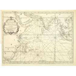
Carte de l'Ocean Oriental ou Mer des Indes. . .
Jacques Nicolas Bellin (1702-720) was the most important French hydrographer of the 18th century. Sea-atlas 'Hydrographique Français' , 1756-65, atlas to accompany Prév...
Place & Date: Paris, ca 1749
Selling price: $130
Sold in 2020
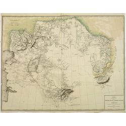
Partie Orientale de l'Empire de Russie en Asie.
Detailed map of the north-eastern part of Russia, including Siberia.
Place & Date: Paris, 1752
Selling price: $100
Sold in 2009
Carte de L'Ocean Oriental ou Mer des Indes..
Detailed map of the Indian Ocean depicting incomplete coastline for Western Australia marked with seven place names, including 'Baye des Chiens Marins veue par Dampierre ...
Place & Date: Paris, 1753
Selling price: $220
Sold in 2011
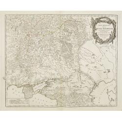
Partie Méridionale de la Russie Européenne . . .
Detailed map of Ukraine, the Crimea and the northern part of the Caspian Sea.
Place & Date: Paris, 1753
Selling price: $100
Sold in 2009
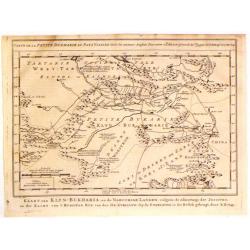
Kaart van Klyn-Bukharia, en de Nabuurige Landen.
Interesting map of Klyn-Bukharia and Nabuurige Countries, which includes Central Asia and the current countries of Kazakstan, Turkmenistan, Uzbekistan, Tajikistan, and Ky...
Place & Date: The Hague, 1757
Selling price: $25
Sold in 2017
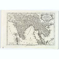
The East Indies, distinguishing the Empires and Kingdoms on the Continent commonly call'd India.
A typical mid eighteenth century mid-sized French map of the East Indies showing India, Tibet, Burma, Siam, Cambodia, Laos and down to Malaysia.Semi-decorative title cart...
Place & Date: Paris, ca. 1760
Selling price: $90
Sold in 2017
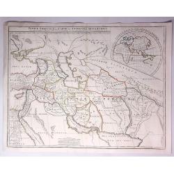
Orbis Romani Pars Orientalis Auspiciis Serenissimi Principis....
Large format map of the Eastern part of the Roman Empire, published by D'Anville. The map extends from Greece and the Balkans in the west to Iran in the east, and is cent...
Place & Date: Paris, 1764
Selling price: $60
Sold in 2016
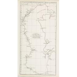
Carte des Isles Nicobar... (with) Plan particulier du Port compris entre les Isles Nacaveri, Souri, et Tricutte.
French of Isles of Nicobar in Gulf of Bengal near Birmanie and Sumatra. Prepared by Jacques-François L'Abbé Dicquemare (1733-1789). Latitude and longitude scales, comp...
Place & Date: Paris, Brest, chez Demonville, 1775
Selling price: $100
Sold in 2015
Chart of the Northern Part of the Bay of Bengal.. Plan de la Rivière de Surate.
French chart of the northern part of the bay of Bengal. Laid down from the surveys made by Bartholomen Plaisted and John Ritchie. Milestone chart prepared by Alexander Da...
Place & Date: Paris, ca 1775
Selling price: $150
Sold
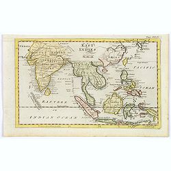
East Indies.
A nice map of the East Indies by Bell from the Encyclopaedia Britannia, or a Dictionary of Ats, Sciences etc. published in London in the last quarter of the eighteenth ce...
Starting Bid: $40
BidAsk spread: $50 - $80
Maker / Publisher: BELL, A.Place & Date: London, 1778
An Accurate Map of the East Indies.
A detailed map of India and Indo China from Middleton's "Complete System of Geography".
Place & Date: London, 1779
Selling price: $120
Sold
Essai d'une nouvelle carte de la Mer Caspienne.
Map of the Caspian Sea including cities/towns and regions. Engraved by de master engraver Guill. De-la-Haye., dated "Novembre 1754". Jean Baptiste Bour...
Place & Date: Paris, c. 1786
Selling price: $100
Sold in 2009
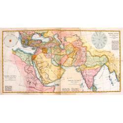
Imperia Antiqua.
Three maps that were joined together as planned and depict the eastern part of the Mediterranean, the Near East and the Indian subcontinent. They came from "Atlas En...
Place & Date: Paris, 1787
Selling price: $150
Sold in 2014
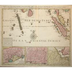
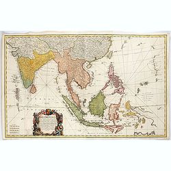
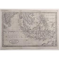
Partie de la Nouvelle Grande Carte des Indes Orientales.. 4 parts
Decorative and complete set of four scarce maps detailing all of Southeast Asia, filled with meticulous topography and place names.1) Partie de la Nouvelle Grande Carte d...
Place & Date: Amsterdam, 1792
Selling price: $1500
Sold in 2008
East Indies.
A lovely little late nineteenth century copperplate map of the East Indies.
Place & Date: London, ca. 1797
Selling price: $75
Sold in 2017
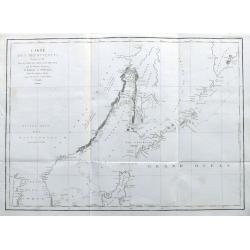
Carte des Découvertes Faites en 1787 dans les Mers de Chine et de Tartarie par les Frégates Françaises la Boußole et l'Astrolabe depuis leur Départ de Manille. . .
A nice large chart of the Asian coast, with parts of Korea, the Russian coast, the Sea of Okhotsk, the Sea of Japan, Hokkaido with unfinished coastline, Sakhalin, and of ...
Place & Date: Paris, 1797
Selling price: $200
Sold in 2022
East Indies from the Best Authorities.
Striking map of the East indies extending from India to the Philippines, including Malaysia, Java, Sumatra, Borneo and the north of New Holland (Australia). Engraved by R...
Place & Date: London, 1798
Selling price: $50
Sold in 2021
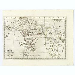
Le Indie Orientali.
A nice map of the East Indies, published in Rome at the beginning of the nineteenth century. Shows from the Persian Gulf across Pakistan, India, and Bangladesh, then sout...
Place & Date: Rome, ca 1803
Selling price: $7
Sold in 2021
Indostan, presqu'isles de l'Inde, Chine, Tartarie Indépendendante.
Map of Hindustan, the Indian peninsula , China, and Tartary. By C. F. Delamarche, successor of Robert de Vaugondy, Geographer.Uncommon later edition with the date 1806. ...
Place & Date: Paris, 1806
Selling price: $80
Sold in 2009
Inde en deca et au dela Du Gange.
Lapie's map of India below and beyond the River Ganges. The map extent is from modern Pakistan and Afghanistan in the west across India and Tibet to southern China, from ...
Place & Date: Paris, 1812
The Islands of the East Indies with the Channels between India, China & New Holland.
A detailed map of Southeast Asia, covering the region between Formosa and Hainan islands in the North and Australia in the South. With excellent detail in the Philippines...
Place & Date: London, 1814
Selling price: $150
Sold in 2018
East India Islands.
A simple map of the East Indies depicting the lands from Arakan in the Bay of Bengal, across today's Vietnam, Laos, Cambodia to the Island of Formosa (Taiwan) off the Chi...
Place & Date: London, 1820
Partie Orientale de la Carte des Anciennes Monarchies...
A striking map depicting the eastern part of the ancient world including the Near East, Cyprus, Black Sea Iran & Iraq by Gilles de Vaugondy, and later improved and re...
Place & Date: Paris, 1822
Selling price: $20
Sold in 2017
![[Kovek dress attire].](/uploads/cache/25832-250x250.jpg)
[Kovek dress attire].
Aquatint depicting dogs pulling a sleigh engraved by D.K. Bonatti, after drawings by C. Bottigella of a family of Turkestan. Plate N° 38 From Giulio Ferrario's work Le C...
Place & Date: Milan, 1827
Selling price: $100
Sold in 2012
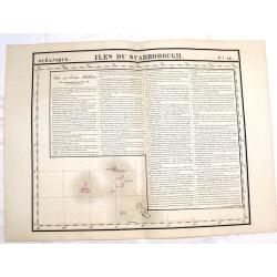
Iles du Scarborough (Oceanique No. 16).
Fine, large, hand-colored, lithographed map of the Scarborough Islands in the China Sea. The ownership is disputed between China, Taiwan, and the Philippines. Engraved by...
Place & Date: Brusselles, 1827
Selling price: $89
Sold in 2015
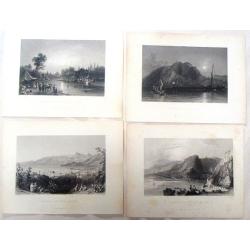
(Four fine Bartlett steel engravings with Middle East Prints.)
Four fine steel engraving prints by William Bartlett. Included are: - THE MOUTH OF THE NAHR-EL-KELB - BEIROUT AND MOUNT LEBANON - MOUNT CASIUS FROM THE SEA - THE RIVE...
Place & Date: London, 1836
Selling price: $12
Sold in 2017
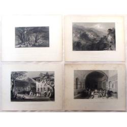
Four Bartlett steel engravings of the Middle East.
Four fine steel engraving prints by William Barlett. Included are: - A TURKISH DEVAN - DEMASCUS - HOUSE OF GIRIUS ADEEB, AT ANTIOCH - THE PASS OF BEILAN -- MOUNT ANANUS...
Place & Date: London, 1836
Selling price: $10
Sold in 2016
Carte du pays occupé par les Kirghiz-Kazaks ou Kirghiz-Kaïssaks. . .
Map representing Kazakhstan, Uzbekistan, Turkmenistan, northern part of Afghanistan, with the Caspian Sea in the west.
Place & Date: Paris, 1840
Selling price: $200
Sold in 2011
East India Islands.
Uncommon map of Indonesia, with nice detail on Philippines, published by Thomas Kelly, 17 Paternoster Row, London.The map appeared in 'Kelly's New System of Universal Geo...
Place & Date: London, 1841
Selling price: $100
Sold in 2018
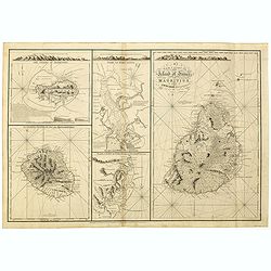
A New chart of Island of France or MAURITIUS by J.N. Norie, 1832. The island of Bourbon, called also Mascarenthas.
Five charts on one sheet, including " A New chart of Island of France or MAURITIUS", "The island of Bourbon, called also Mascarenthas", "Plan of ...
Place & Date: London, 1854
Selling price: $1000
Sold in 2018
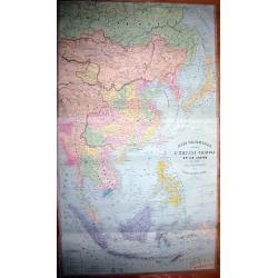
ASIE ORIENTALE comprenant L'EMPIRE CHINOIS ET LE JAPON LES ETATS DE L'INDO-CHINE ET LE GRAND ARCHIPEL D'ASIE
Early edition of the rare wall-map of the Far East by Andriveau-Goujon. Shows the Far East, from Russia, with Tibet, China, Korea, Thailand, Singapore, Indonesia, unti...
Place & Date: Paris, 1862
Selling price: $210
Sold in 2011
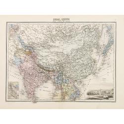
Inde, Chine
Decorative map of India and China from Géographie Universelle, Atlas Migeon. published by J. Migeon. Engraving by Schroeder of a view of Calcutta in the lower right corn...
Place & Date: Paris 1874
Selling price: $20
Sold
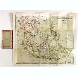
East Indies. (Malay, or East Indian Archipelago with Burma & Siam)
Folding map of the East Indies, Indonesia, Indochina, Thailand, Burma, the Malay Peninsula, Borneo, the Philippines, Sumatra, Java, Celebes.Sifton, Praed & Co., Ltd. ...
Place & Date: London, ca. 1930
Selling price: $120
Sold in 2017
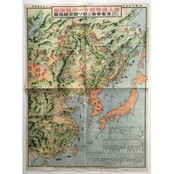
Hitome de wakaru Shina jihen to Nisso kankei echizu - Map of East Asia and Soviet, detailing the development of the Sino-Japanese Conflict
The main map includes numerous pictorial features of people in each country and region on the map. Names of major cities are given, and several charts, such as a chronolo...
Place & Date: Japan, 1937
Selling price: $265
Sold in 2016
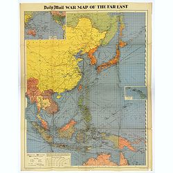
War Map of the Far East.
A large multi-colored poster of the War in the Far East, published by the Daily Mail Newspaper. Map extends from the northern tip of Australia in the south, northward up ...
Place & Date: London, 1944
Selling price: $80
Sold in 2018