Browse Listings in Antique Maps > America > North America > North Pole
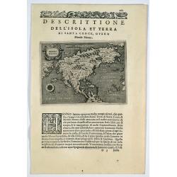
Descrittione dell' isola et terra di Santa Croce, overo Mondo Nuovo.
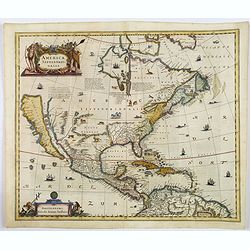
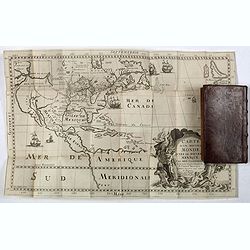
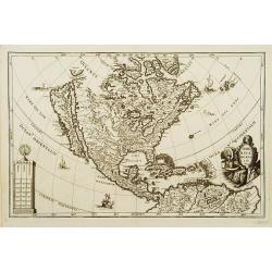
Porcacchi's map of North America, set in a page of text From "L'Isole piu famoso del mondo”. This is the second earliest obtainable map of North America, preceded ...
Place & Date: Venice, 1572-1585
Selling price: $550
Sold in 2019
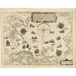
Deliniatio cartae trium navigationum per Batavos..
A major landmark in Arctic cartography incorporating recent voyages including Barents' third voyage to this region, made in 1596-7. A derivative of Willem Barentsz's map ...
Place & Date: Frankfurt 1599
Selling price: $2150
Sold
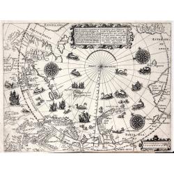
Deliniatio cartae trium navigationum per Batavos. . .
A major landmark in Arctic cartography incorporating recent voyages including Barents' third voyage to this region, made in 1596-7. A derivative of Willem Barentsz's map ...
Place & Date: Frankfurt, 1599
Selling price: $1900
Sold in 2012
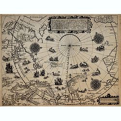
Deliniatio cartae trium navigationum per Batavos..
A major landmark in Arctic cartography incorporating recent voyages including Barents' third voyage to this region, made in 1596-7. A derivative of Willem Barentsz's map ...
Place & Date: Frankfurt, 1599
Selling price: $2500
Sold in 2017
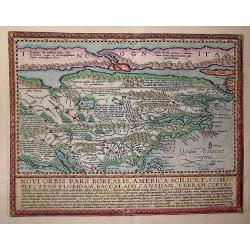
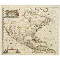
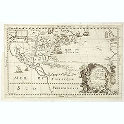
Novi Orbis Pars America. . .
Published in Cologne in 1600 this map is from 'Geographisch Handtbuch' with German text on the verso.Quad's map of North America is derived from De Jode and is a beautifu...
Place & Date: Cologne, 1600
Selling price: $2300
Sold in 2013
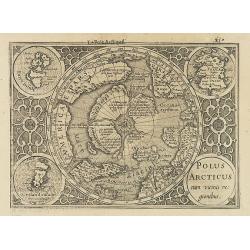
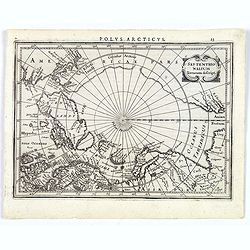
Polus Arcticus cum vicinis regionibus.
Map of the North Pole regions from the 1608 second edition of Jodocus Hondius' Atlas Minor.A reduction of the 1606 Mercator-Hondius folio map (which is a later state of t...
Place & Date: Amsterdam, 1608
Selling price: $500
Sold in 2012
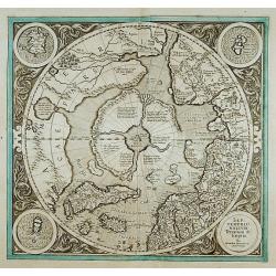
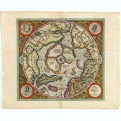
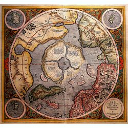
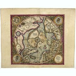
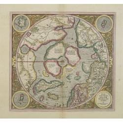
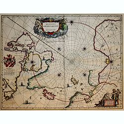
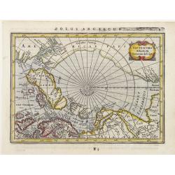
SEPTENTRIONALIUM Terrarum descriptio. Per Gerardum Mercatore
State 2. This is the first map devoted to the Arctic, a hemispherical one on a North Polar projection with an attractive floral design surrounding it. In the corners are ...
Place & Date: Amsterdam 1609
Selling price: $1325
Sold
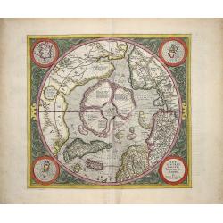
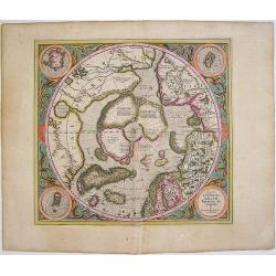
SEPTENTRIONALIUM Terrarum descriptio. Per Gerardum Mercatore.
State 2. This is the first map devoted to the Arctic, a hemispherical one on a North Polar projection with an attractive floral design surrounding it. In the corners are ...
Place & Date: Amsterdam, 1609
Selling price: $2450
Sold in 2013
Septentrionalium Terrarum descriptio. Per Gerardum Mercatorem Cum Privilegio.
State 2. This is the first map devoted to the Arctic, a hemispherical one on a North Polar projection with an attractive floral design surrounding it. In the corners are ...
Place & Date: Amsterdam, 1609
Selling price: $2000
Sold in 2015
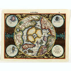
Septentrionalium Terrarum descriptio
This influential map was the first separately printed map devoted to the Arctic. The hemisphere is surrounded by a floral design with four roundels in each corner. These ...
Place & Date: Amsterdam, 1611
Selling price: $1150
Sold in 2011
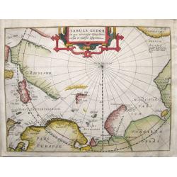
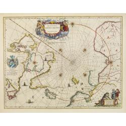
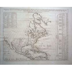
Tabula Geogr. in qua admirandae navigationis cursus et recursus designatur.
First state of a very early and scarce map of the North Pole and Arctic regions showing recent discoveries including the voyage of Jan Willem Barentsz on his quest to fin...
Place & Date: Amsterdam, 1611
Selling price: $850
Sold in 2016
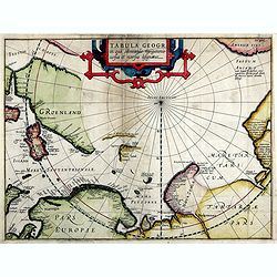
Tabula Geogr. In qua admirandae navigatonis..
A finely engraved map by Jodocus Hondius with coastline details of northern Europe, Greenland, Frisland, Strait Anian with America pars. With the track of a Willem Barent...
Place & Date: Amsterdam, 1614
Selling price: $740
Sold in 2019
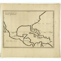
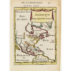
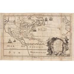
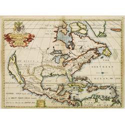
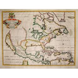
Descripcion De Las Yndias Del Norte.
Map of the Southern United States, Mexico, Central American and the Caribbean, from his Description des Indes Occidentales Qu'on appelle aujourdhuy Le Nouveau Monde. . fi...
Place & Date: Amsterdam, Michel Colin, 1622
Selling price: $700
Sold in 2017
SEPTENTRIONALIUM Terrarum descriptio. Per Gerardum Mercatore
State 2. This is the first map devoted to the Arctic, a hemispherical one on a North Polar projection with an attractive floral design surrounding it. In the corners are ...
Place & Date: Amsterdam, 1623
Selling price: $2100
Sold in 2016
SEPTENTRIONALIUM Terrarum descriptio. Per Gerardum Mercatore
State 2. This is the first map devoted to the Arctic, a hemispherical one on a North Polar projection with an attractive floral design surrounding it. In the corners are ...
Place & Date: Amsterdam, 1623
Selling price: $1500
Sold in 2019
![[Unmounted gores from a very rare Dutch Globe]](/uploads/cache/46309-250x250.jpg)
[Unmounted gores from a very rare Dutch Globe]
These rare gores are very possibly the only surviving examples from a 17 inch (44cm) diameter globe by Hondius and Janssonius. It is believed that only four of five examp...
Place & Date: Amsterdam, ca 1623
Selling price: $7600
Sold in 2020
Septentrionalium Terrarum decsript.
A good example of Mercator-Jansson's small map of the North Polar regions.The map is extended to 60 degrees, to show the recent explorations in search of the North West a...
Place & Date: Amsterdam, ca. 1628
Selling price: $195
Sold in 2017
Septentrionalium Terrarum descriptio.
The classic map of the Arctic region, representing the late Medieval concept of four islands surrounding a centralized whirlpool. This polar depiction was an expansion of...
Place & Date: Amsterdam, 1630
Selling price: $1600
Sold in 2009
Septentrionalium Terrarum descriptio.
Artic pole map from the rare Cloppenburg edition slightly larger format and more scarce edition of the Mercator/Hondius "Atlas Minor". The classic map of the Ar...
Place & Date: Amsterdam, 1630
Selling price: $230
Sold in 2020
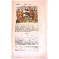
![[American history plate].](/uploads/cache/40178-250x250.jpg)
[American history plate].
Scarce print (150x177mm.) on a German text sheet taken from a first edition of Johann Ludwig Gottfried's "Newe Welt Vnd Americanische Historien/ Jnhaltende Warhaffti...
Place & Date: Frankfurt, M.Merian, 1633
Selling price: $50
Sold in 2018
![[American history plate].](/uploads/cache/40185-250x250.jpg)
[American history plate].
Scarce print (150x177mm.) on a German text sheet taken from a first edition of Johann Ludwig Gottfried's "Newe Welt Vnd Americanische Historien/ Jnhaltende Warhaffti...
Place & Date: Frankfurt, M.Merian, 1633
Selling price: $50
Sold in 2018
![Insulae Americanae in Oceano Septentrionali, cum terris adjacentibus [Rare Blaeu West Indische Pascaert Wall Map Section]](/uploads/cache/36201-250x250.jpg)
Insulae Americanae in Oceano Septentrionali, cum terris adjacentibus [Rare Blaeu West Indische Pascaert Wall Map Section]
On 11 February 1634 Willem Blaeu announced the publication of a world atlas in four languages. He was able to complete only the German edition in that year. In order to g...
Place & Date: Amsterdam, 1634
Selling price: $11500
Sold in 2015
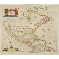
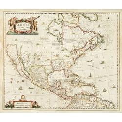
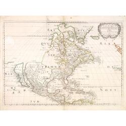
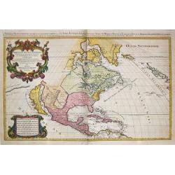
America septentrionalis.
A first state of this important map showing California as an island. Lacking any imprint in the cartouche lower left. From the first French text edition. The north west o...
Place & Date: Amsterdam 1639
Selling price: $4500
Sold
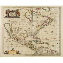
America Septentrionalis.
Showing California as an island, and above, the north west of the continent left blank except for two legends explaining the discoveries to that date. The Hudson Bay is c...
Place & Date: Amsterdam 1640
Selling price: $4600
Sold
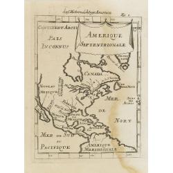
Regiones Sub Polo Arctico.
One of the many cases of duplication by the firms of Blaeu and Hondius/Jansson. In this case, Blaeu has copied Jansson's map of 1637. It depicts rhumb lines radiating fro...
Place & Date: Amsterdam, 1640
Selling price: $800
Sold in 2009
Description de la Nouvelle France ou sont remarquees les diverse habitations des Francois, depuis la premiere descouvert jusques a present, recueillie et dressee sur diverses relations modernes
VERY RARE FIRST STATE, a second state was issued circa 1664. In superb condition. Important GREAT LAKES map first issued in 1643. According to Burden it is actually the f...
Place & Date: Paris, 1643
Selling price: $26000
Sold in 2012
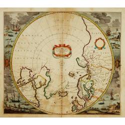
Poli Arctici et Circumiacentium Terrarum Descriptio.
A circular map showing north of Europe and United States. The map is surrounded by scenes of fishing whales.
Place & Date: Amsterdam 1639-1644
Selling price: $1200
Sold
Poli Arctici et Circumiacentium Terrarum Descriptio.
A circular map showing north of Europe and United States. The map is surrounded by scenes of fishing whales. Cartographically the map incorporates much of the knowledge g...
Place & Date: Amsterdam, 1639-1644
Selling price: $1150
Sold in 2012
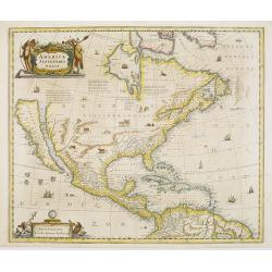
America Septentrionalis.
Showing California as an island, and above, the north west of the continent left blank except for two legends explaining the discoveries to that date. The Hudson Bay is c...
Place & Date: Amsterdam 1647
Selling price: $3100
Sold
America Septentrionalis.
Showing California as an island, and above, the north west of the continent left blank except for two legends explaining the discoveries to that date. The Hudson Bay is c...
Place & Date: Amsterdam 1647
Selling price: $3900
Sold
America Septentrionalis.
Showing California as an island, and above, the north west of the continent left blank except for two legends explaining the discoveries to that date. The Hudson Bay is c...
Place & Date: Amsterdam, 1647
Selling price: $2700
Sold in 2008
Regiones Sub Polo Arctico.
A fine Blaeu version of the Janssonius map of 1637. It depicts rhumb lines radiating from the North Pole. A large title cartouche, with two figures and numerous wind head...
Place & Date: Amsterdam, 1647
Selling price: $490
Sold in 2017
Septentrionalium Terrarum Descript.
Detailed miniature map of the North Pole, from a German text edition of his Atlas Minor. Engraved by Petrus Kaerius.
Place & Date: Amsterdam (1628) 1648
Selling price: $110
Sold
Mexicum in hac forma in lucem edebat IOANNES BAPTISTA NICOLOSIVS S.T.D.
The first state of Nicolosi's rare and important map of south-western North America. Although the Spanish settlements in New Mexico were already more than half a century ...
Place & Date: Rome 1650
Selling price: $6000
Sold
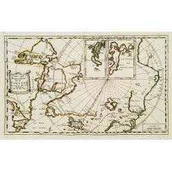
Pais qui dependent de la Norvege suivant les derniers relations.
Rare map of the North Pole. With inset maps of Faeroe and Shetland Islands.
Place & Date: Paris 1650
Selling price: $285
Sold
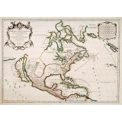
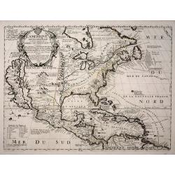
Amerique Septentrionale par N. Sanson.
Decorative and important map of the Americas with a CALIFORNIA AS AN ISLAND. Engraved by Abraham Peyrounim (c.1620 - c.1666).Sanson's map of North America is the first to...
Place & Date: Paris, after 1650
Selling price: $2200
Sold in 2014
America Septentrionalis.
A wonderful map showing California as an island, and above, the north west of the continent left blank except for two paragraphs explaining the discoveries to date. Inter...
Place & Date: Amsterdam, ca 1650
Selling price: $1900
Sold in 2019
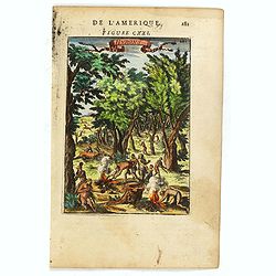
Native Americans Bring Food & Water & Treasure.
Fine Historical hand-colored copperplate engraving featuring Native Americans bringing food and treasure. Arnoldus Montanus (1625–1683) was a Dutch teacher and author....
Place & Date: Amsterdam. 1671
Selling price: $21
Sold in 2013
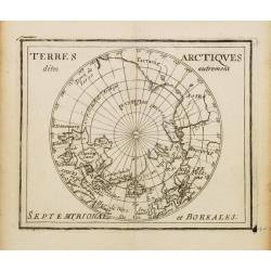
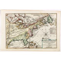
Terres Arctiques.. Septemtrional et Boreales.
Uncommon miniature map of the North Pole, including Iceland, the coast of Russia, Greenland, etc, from Pierre Duval's La Geographie Universeille dated 1676. Following his...
Place & Date: Paris, 1676
Selling price: $300
Sold
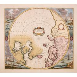
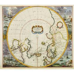
Poli Arctici, et circumiacentium terrarum descriptio novissima. . .
A re-issue of the Hondius' plate, but without the signature. A particularly decorative map of the North Pole. Several Dutch names in Labrador. The toponymy in Canada refl...
Place & Date: Amsterdam, ca.1676
Selling price: $2025
Sold in 2016
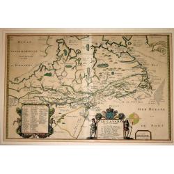
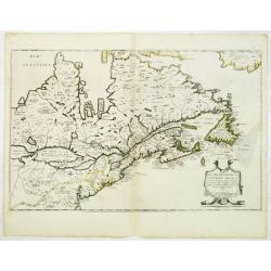
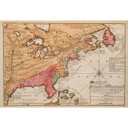
Le Canada faict par le St. de Champlain..
The fourth printed state of Champlain's 1616 plate of Canada. According to Wroth, Du Val somehow came into possession of the Champlain plate, printed a proof state, then ...
Place & Date: Paris, 1677
Selling price: $3700
Sold in 2012
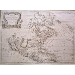
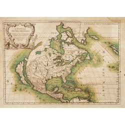
L'America Settentrionale.
Full title: 'L' America Settentrionale. Nuouamente corretta, et accresciuta secondo le relationi piu moderne, da GVGLIELMO SANSONE Geografe di S M Chrisftianis. E data in...
Place & Date: Rome, 1677
Selling price: $1700
Sold in 2015
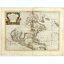
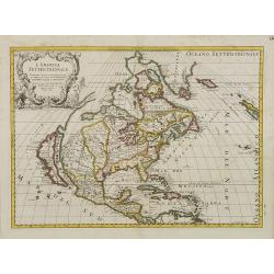
L' America Settentrionale. Nuouamente corretta, et accresciuta secondo le relationi piu moderne, da GVGLIELMO SANSONE. . .
Rossi's map of North America, based upon Sanson's seminal map, but with revised Italian nomenclature. Includes a detailed California as an Island on Sanson's model, and e...
Place & Date: Rome, 1677
Selling price: $1000
Sold in 2015
American Family at Rest.
Interesting map of a Native American family at rest. It gives an indication of dress, foods and customs. Olfert Dapper (1635 – 1689) was a Dutch physician and writer....
Place & Date: Amsterdam, 1681
Selling price: $20
Sold in 2015
Amerique Septentrionale.
A charming late 17th century French map of North America, showing California to 40 degrees North and labelled I.Calfornie.
Place & Date: Paris 1683
Selling price: $110
Sold
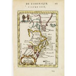
Canada ou Nouvelle France.
A charming late 17th century French map of east coast of Canada and North America.Greenland drawn close to the Canadian coast. The Great Lakes are shown open-ended in the...
Place & Date: Paris, 1683
Selling price: $50
Sold
Amerique Septentrionale.
A charming late 17th century French map of North America, showing California to 40 degrees North and labelled I.Calfornie.
Place & Date: Paris, 1683
Selling price: $50
Sold in 2008
Canada ou Nouvelle France. (together with) United States.
A strange early depiction of the Eastern Seaboard, from Terres Arctiques Incognues to Virginie, including also an outline of the Great Lakes. Native Indians appear at the...
Place & Date: Paris, 1683
Selling price: $120
Sold in 2012
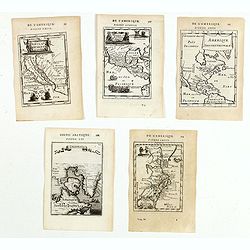
(Five maps of North American interest from Description de l\'Univers)
Finely etched maps entitled : Nouveau Mexique et Californie, Mexique et nouvelle Espagne, Amerique Septentrionale, De l'Amerique, Groenlande".From the French text ed...
Place & Date: Paris, 1683
Selling price: $275
Sold in 2015
Hurons.
Attractive copper engraving, depicting Huron Indians or Wynadot / Wendat people hunting and gathering .
Place & Date: Paris, 1683
Selling price: $25
Sold in 2016
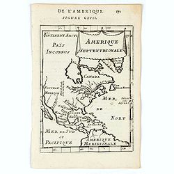
Amerique Septentrionale.
A charming map of North America with the island of California shown only to about the 40 degrees north. The Great Lakes are open-ended in the west and called Mer Douce an...
Place & Date: Paris, 1683
Selling price: $170
Sold in 2020

Amerique Septentrionale.
A charming late 17th-century French map of North America, showing California to 40 degrees North and labeled I.Calfornie.From the German text edition published by Davis Z...
Place & Date: Frankfurt, 1684
Selling price: $100
Sold in 2008
Amerique Septentrionale.
Alain Manneson Mallet (1603-1706) published in 1683 his ' Description de l' Univers' in 5 volumes. In 1686 a German edition appeared.Allain Mallet's attractive little map...
Place & Date: Frankfurt, 1686
Selling price: $200
Sold in 2008
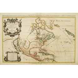
L'America Settentrionale..
Second edition of Rossi's map of North America, based upon Sanson's seminal map, but with revised Italian nomenclature. From Rossi's Mercurio Geographico..Includes a deta...
Place & Date: Rome 1687
Selling price: $2025
Sold
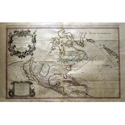
L'America Settentrionale. Nuovamente Corretta et Accresciuta Secondo le Relationi Piu Moderne da Guglielmo Sansone Geografo . . . 1687 (California as an island)
Second edition of Rossi's map of North America, based upon Sanson's seminal map, but with revised Italian nomenclature. From Rossi's Mercurio Geographico..Includes a deta...
Place & Date: Rome, 1687
Selling price: $2000
Sold in 2012
Amerique septentrionale.
Engraved by Cordier. Spectacular example of Jaillot's map of North America, showing California as an Island, based upon Sanson's landmark map of 1656. This map shows the ...
Place & Date: Paris, 1692
Selling price: $2125
Sold
Amerique Septentrionale divisée en ses principales parties?
Impressive map of North America, prepared by Nicolas Sanson and published by Pierre Mortier in Amsterdam. The map is copied from Jaillot's map of 1674 and only some small...
Place & Date: Amsterdam, 1692
Selling price: $1650
Sold in 2008
Amérique septentrionale divisée en ses principales parties..
Engraved by Cordier. Spectacular example of Jaillot's map of North America, showing California as an Island, based upon Sanson's landmark map of 1656. This map shows the ...
Place & Date: Paris, 1695
Selling price: $1725
Sold
Amerique septentrionale / divisee en ses principales parties. Paris, 1695.
Alexis-Hubert Jaillot (1632-1712), French cartographer. He joined the Sanson heirs and redrew Nicolas Sanson's maps on a larger scale. 'Atlas Nouveau' (1674), sea-atlas '...
Place & Date: Amsterdam, 1696
Selling price: $3200
Sold
L'Amérique septentrionale et les terres polaires arctique (sic) / dressée par N. de Fer.
An interesting small map of North America by Nicolas de Fer. From his rare "Petit et Nouveau Atlas". The first edition was published in 1697 and was republished...
Place & Date: Paris,1697
Selling price: $240
Sold in 2016
Carte d'un Nouveau Monde, entre le Nouveau Mexique et la Mer Glaciale ...
Map of America from Nouveau Voyage d'un Pays plus grand que l'Europe ... by R. P. Louis Hennepin, published in Utrecht in 1698.Based on his 1683 map Carte de la Nouvelle ...
Place & Date: Utrecht, 1698
Selling price: $425
Sold in 2014
Nouveau Voyage d'un Pais Plus Grand que l'Europe.
FIRST EDITION OF THE BOOK. This edition of Hennepin's writings, a continuation of his Nouveau voyage of the previous year, comprises materials about La Salle taken from C...
Place & Date: Utrecht, [E. Voskuyl for] Antoine Schouten, 1698
Selling price: $6000
Sold
Carte D'un Nouveau Monde, entre le Nouveau Mexique, et la Mer Glacialle Novellement decouvert par le R.P. Louis Hennepin...
Extremely rare second edition of Louis de Hennepin’s map of North America, which incorporates many of the discoveries omitted by Hennepin in the first edition of his ma...
Place & Date: Paris, 1698
Selling price: $3000
Sold in 2021

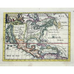
Repraesentatio Americae Borealis...
An interesting religious map of North America, showing the Catholic regions illuminated and the Protestant and still uncolonized lands swathed in darkness. California is ...
Place & Date: Munich 1699
Selling price: $850
Sold
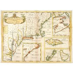
A new map of.. Plantations of the English in America..
"A boldly engraved large-scale map of the Carolinas, Nova Scotia, Bermuda, Barbados and Jamaica appear as large insets on this interesting uncommon and attractive ma...
Place & Date: London 1700
Selling price: $1600
Sold
L'Amerique Septentrionale dressée sur les Observations de Mrs de l'Academie Royale des Sciences . . .
Rare third state of "L’Amerique Septentrionale. Chez l’Auteur sur le Quai de l’Horloge a la Cour. de Diamans avec Privilege du Roy pour 20 ans, 1700". &qu...
Place & Date: Paris, 1700
Selling price: $3500
Sold in 2018
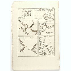
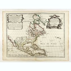
Carver's new map of North America. . .
6 maps on a sheet Carver's map of North America, among other maps of Strait Anian.
Place & Date: England, ca. 1700
Selling price: $80
Sold in 2020
America borealis 1699.
A map from the series of maps by the Jesuit mathematician. One of the two maps of North America from the series of about six of North America, produced by Scherer to show...
Place & Date: Munich c.1702
Selling price: $580
Sold
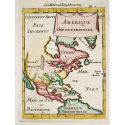
Provinciae Borealis Americae non ita Pridem Detectae aut Magis ab Europaeis Excultae.
This captivating map of North America features a huge island of California, an oversized depiction of the Great Lakes, and a misplaced Mississippi River delta. The interi...
Place & Date: Munich, 1702
Selling price: $850
Sold in 2012
L\'Amerique septentrionale. Noord America.
Map of North and Central America showing California as an island with indented coastline, and with place names R'Estiete, C.Blanco, P.de Carinde, Canal de S. Barbe, I. de...
Place & Date: Amsterdam, 1702
Selling price: $250
Sold in 2013
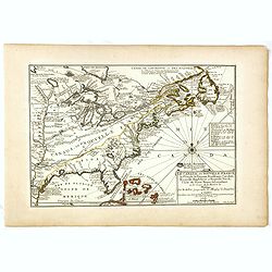
Le Canada, ou Nouvelle France la Florida, la Virginie, Pensilvanie . . .
First edition. This fine map is showing the east coast of the United States from the Caribbean up to Newfoundland, with the western border just beyond the Mississippi.The...
Place & Date: Paris, 1702
Selling price: $500
Sold in 2016
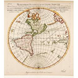
Hemisphere Superieur du Globe Terrestre..
Rare map of Western Hemisphere shown in reverse, but text printed normally. World from internal viewpoint. California with indented northern coast. Terre de Jesso to Nort...
Place & Date: Paris 1704
Selling price: $715
Sold
A New Map of North America Shewing its Principal Divisions, Chief Cities, Townes, Rivers, Mountains & c.
A boldly engraved map of North America, showing California as an island. This is a state 4. California as New Abion discovered by Sir Francis Drake Anno 1577 . Traci now ...
Place & Date: London, 1704
Selling price: $1500
Sold in 2018
A New Map of North America
Title: 'A New Map of North America Shewing its Principal Divisions, Chief Cities, Townes, Rivers, Mountains & c.'. A rare and interesting map of North America. Alth...
Place & Date: London, 1704
Selling price: $2200
Sold
L'Amerique Septentrionale, ou la Partie Septentrionale des Indes Occidentales ou se Trouve le Canada ou Nouvelle France la Floride la Virginie les Isles Antilles le Nouveau Mexique et la Nouvele Espagne.
“Vincenzo Maria Coronelli’s large two-sheet ‘AMERICA SETTENTRIONALE,’ dated 1688, did not appear in an atlas until 1691, in the first edition of the ‘Atlante Ve...
Place & Date: Paris, 1689-1704
Selling price: $1850
Sold in 2013
Le Canada, ou Nouvelle France la Florida, la Virginie, ? Misispi
Fine map of the eastern coast of North America. Engraved by Herman van Loon, a Dutch engraver active in Amsterdam, after 1686 in Paris. ¤
Place & Date: Paris, 1705
Selling price: $800
Sold in 2009
Nouvelle Carte de l\' Amerique Septentrionale dressee sur les plus Nouvelles Observations de Messieurs de l\' Academie des Sciences et des Meilleurs Geographes avec des tables tres instructives et curieuses de la division de tous les Etats.
From: Atlas Historique. A fine folio map with California as an island. All five of the Great Lakes are present; but Lake Erie is unnamed. The Ohio River is shown, but unn...
Place & Date: Amsterdam, 1705
Selling price: $250
Sold in 2014
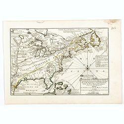
Le Canada, ou Nouvelle France la Florida, la Virginie, Pensilvanie . . .
Fine map is showing the east coast of the United States from the Caribbean up to Newfoundland, with the western border just beyond the Mississippi.The course of the Missi...
Place & Date: Paris, 1705
Selling price: $600
Sold in 2019
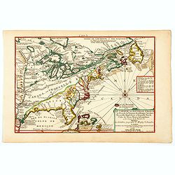
Le Canada, ou Nouvelle France la Florida, la Virginie, Pensilvanie . . .
Fine map is showing the east coast of the United States from the Caribbean up to Newfoundland, with the western border just beyond the Mississippi.The course of the Missi...
Place & Date: Paris, 1705
Selling price: $600
Sold in 2020
Le Canada, ou Nouvelle France la Florida, la Virginie, Pensilvanie . . .
A fine map is showing the east coast of the United States from the Gulf of Mexico and the Caribbean up to Newfoundland, with the western border just beyond the Mississipp...
Place & Date: Paris, 1705
Selling price: $555
Sold in 2021