Browse Listings in Antique Maps > America > North America > Florida
![La Florida [with] Guastecan](/uploads/cache/florida_01-250x250.jpg)
La Florida [with] Guastecan
A fine, old-colored example of Abraham Ortelius’ seminal map of Florida and the North American South. Ortelius’ map La Florida was the foundation for cartography ...
Place & Date: Antwerp, 1590
Selling price: $650
Sold in 2023
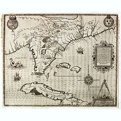
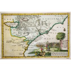
Floridae Americae Provinciae recens & exactissima descriptio . . .
A superb map of the Eastern Seaboard from Cape Lookout to Florida, with Cuba and the Bahamas, by the official artist of the second French Huguenot expedition to their col...
Place & Date: Frankfurt, 1591
Selling price: $5700
Sold in 2019

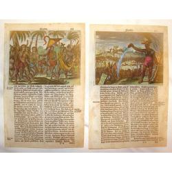
French battle with Florida Indians, 1591
Exciting de Bry engraving from 'der ander Theil der newlich erfundenen Landtschafft Americae' showing French soldiers aiding native North Americans in a war against a riv...
Place & Date: Frankfurt, c.1591
Selling price: $225
Sold in 2014
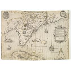
Floridae Americae Provinciae recens & exactissima descriptio . . .
A superb map of the Eastern Seaboard from Cape Lookout to Florida, with Cuba and the Bahamas, by the official artist of the second French Huguenot expedition to their col...
Place & Date: Frankfurt, 1591
Selling price: $1500
Sold in 2014
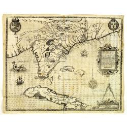
Floridae Americae Provinciae recens & exactissima descriptio . . .
A superb map of the Eastern Seaboard from Cape Lookout to Florida, with Cuba and the Bahamas, by the official artist of the second French Huguenot expedition to their col...
Place & Date: Frankfurt, 1591
Selling price: $12750
Sold in 2012
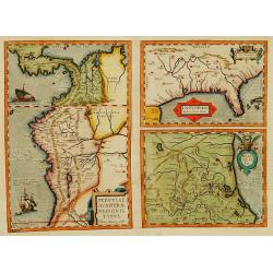
La Florida_Guastecan_Peruviae Avriferae Regionis Typus.
The most important map (La Florida) is the first printed map of the southeastern region of the United States. This influential map provided the foundation cartography for...
Place & Date: 1595
Selling price: $800
Sold in 2017
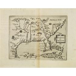
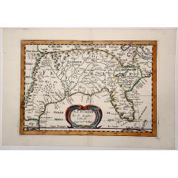
Florida et Apalche.
Very rare sixteenth century map: drawn from the Abraham Ortelius -Gerónimo de Chaves map entitled La Florida, published in 1584. However, here Metellus expands the area ...
Place & Date: Cologne 1598
Selling price: $3125
Sold
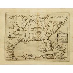
Florida et Apalche.
Wyfliet's map is one of the earliest to focus on the Southeast and to name "Florida", showing part of Texas, Mexico, Cuba, the Bahamas and the Gulf of Mexico.Dr...
Place & Date: Louvain, 1597-1600
Selling price: $2500
Sold in 2020
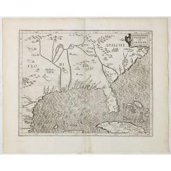
Florida et Apalache.
Very rare map of Florida, including parts of Cuba and the east coast north to the area of the Outer Banks of Carolina. The map is a reduced version of Cornelis Wytfliet m...
Place & Date: Cologne 1600
Selling price: $2000
Sold
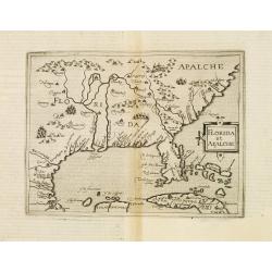
Florida et Apalche.
Very rare map of Florida, including parts of Cuba and the east coast north to the area of the Outer Banks of Carolina. The map is a reduced version of Cornelis Wytfliet m...
Place & Date: Cologne, 1600
Selling price: $3300
Sold in 2013
Peruviae Auriferae.. La Florida.. Guatecan..
Didacus Mendezius' is mentioned on the map as the author of the map, however this person is unknown in cartographical history. Possibly, it derives from Don Diego Hurtado...
Place & Date: Antwerp 1584-1603
Selling price: $1900
Sold
Peruviae Auriferae Regionis Typus. - La Florida - Guastecan.
[3 maps: Florida, Peru and Mexico.] "The Florida map is one of the very few maps printed in the sixteenth century that was based upon original Spanish sources. They ...
Place & Date: Antwerp, 1603
Selling price: $780
Sold in 2019
![[Drake capturing of St. Augustine in Florida].](/uploads/cache/39913-250x250.jpg)
[Drake capturing of St. Augustine in Florida].
Scarce print with a German text sheet showing Drake's men overrunning the settlement of St. Augustine. Fleet is anchored in the bay. From de Bry's "Great American Vo...
Place & Date: Frankfurt, M. Merian, 1633
Selling price: $210
Sold in 2017
![[How the Indians treat their sick] / [The sacrifice of the first born].](/uploads/cache/41096-250x250.jpg)
[How the Indians treat their sick] / [The sacrifice of the first born].
Two engravings. [385] They lay the sick person down upon a wooden bench. Then they cut the skin of his forehead with a sharp shell and sucked out the blood with their own...
Place & Date: Frankfurt, M.Merian, 1633
Selling price: $72
Sold in 2020
![[The retaking of Fort Caroline by the French / Indians from the Spanish.]](/uploads/cache/40469-250x250.jpg)
[The retaking of Fort Caroline by the French / Indians from the Spanish.]
A lively battle scene with cannons roaring, dead bodies strewen all over the ground, boats and soldiers crossing a river. This is the epic battle scene of the combined fo...
Place & Date: Frankfurt, M.Merian, 1633
Selling price: $90
Sold in 2018
![[The Spanish capture Fort Caroline].](/uploads/cache/40183-250x250.jpg)
[The Spanish capture Fort Caroline].
The Spanish capture Fort Caroline in Florida. Fort Caroline was an attempted French colonial settlement in Florida, located on the banks of the St. Johns River in present...
Place & Date: Frankfurt, M.Merian, 1633
Selling price: $140
Sold in 2020
![[Fort Caroline] / [Indians worship the stone column].](/uploads/cache/41089-250x250.jpg)
[Fort Caroline] / [Indians worship the stone column].
Two engravings. [375] When this fort was completed, the French named it Fort Caroline. The sides facing westward were defended by a ditch and ramparts built up with soil ...
Place & Date: Frankfurt, M.Merian, 1633
Selling price: $95
Sold in 2018
La Floride.
Map of Florida, from the first edition of the atlas L'Amérique en plusieurs cartes, et en divers traittés de Géographie, et d'Histoire.Nicolas Sanson was to bring abou...
Place & Date: Paris, 1657
Selling price: $350
Sold in 2013
La Floride . . .
Map of Florida prepared by N.Sanson and published by Pierre Mariette.Published in an early edition of the small Sanson atlas L'Europe Dediée a Monseigneur . . . Le Telli...
Place & Date: Paris, P. Mariette, 1667
Selling price: $465
Sold in 2008
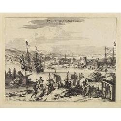
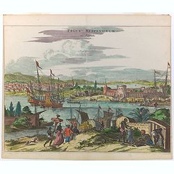
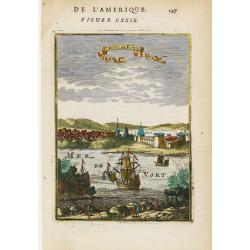
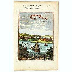
Pagus Hispanorum in Florida.
View of the port of St. Augustine, with ships and boats docked before the walled town, a few slaves and natives tending to their Spanish overlords.
Place & Date: Amsterdam, 1671
Selling price: $405
Sold
Arx Carolina.
A superb 17th century copperplate engraving displaying Fort Carole and its surrounds on the St. John's River in Florida. It is situated in what today is Jacksonville, in ...
Place & Date: London, ca 1671
Selling price: $200
Sold in 2022
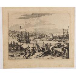
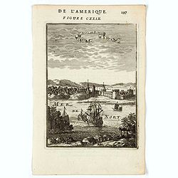
Pagus Hispanorum in Florida.
View of the port of St. Augustine, the oldest city in the United States and the northernmost bastion of the Spanish empire in America (Castillo de San Marcos). With ships...
Place & Date: Amsterdam, 1671
Selling price: $450
Sold in 2020
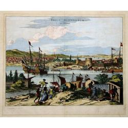
PAGUS HISPANORUM in Florida
Ogilby’s important early view of St. Augustine. With very decorative coloring. This view was originally drawn from Gerrit van Schagen’s work, and depicts a fictional...
Place & Date: London, 1671
Selling price: $190
Sold in 2011
Pagus Hispanorum in Florida.
A nicely colored copperplate view of the port and surrounds of St. Augustine in Florida, one of the oldest cities in what would become the United States. First settled by...
Place & Date: London, ca 1671
La Floride.
Uncommon miniature map of Florida and Louisiana from Pierre Duval's La Geographie Universeille dated 1676.
Place & Date: Paris, 1672
Selling price: $400
Sold in 2013
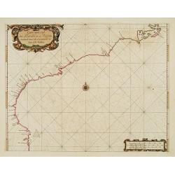
Carte vande Cust van Florida tot de Verginis streckende van Cabo de Carnaveral tot Baya de la Madalena.
An extremely rare and attractive chart of the coast of Florida extending from Cape Canaveral in Florida and following the coasts from South and North Carolina up to Cape ...
Place & Date: Amsterdam 1675
Selling price: $8025
Sold
La Floride.
Uncommon miniature map of Florida from Pierre Duval\'s La Geographie Universeille dated 1676. Following his Cartes de geographie in 1657, Pierre Duval published this smal...
Place & Date: Paris, 1676
Selling price: $220
Sold in 2008
Florida (Two Copper Engravings)
Two Very interesting hand-colored copper engravings featuring Native American in Florida. One is titled ""Native Americans Walk Through Forest" and the oth...
Place & Date: Amsterdam, 1679
Selling price: $80
Sold in 2013
LA FLORIDE
Map of Florida, from the atlas L'Amérique en plusieurs cartes, et en divers traittés de Géographie, et d'Histoire.Nicolas Sanson was to bring about the rise of French ...
Place & Date: Paris 1680
Selling price: $475
Sold in 2019
St. Augus. De Floride.
Handsome view of the St. Augustine on the coast of Florida.From the French text edition of Description d'Univers, 1683. by Allain Manneson Mallet (1630-1706), a well trav...
Place & Date: Paris 1683
Selling price: $55
Sold
St Angus de Floride. (St. Augustine, Florida)
A charming view of St. Augustine, Florida. Title in curtain draped at top. French text on verso.From the original 1683 text edition of "Description d'Univers. . .&qu...
Place & Date: Paris, 1683
Selling price: $100
Sold in 2020
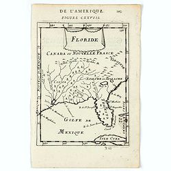
Floride.
A charming map of Florida, also showing Cuba, Golf of Mexico & St Augustine.Title in curtain draped at top. French text on verso.From the original 1683 text edition o...
Place & Date: Paris, 1683
Selling price: $150
Sold in 2020
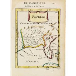
Floride.
Includes much of the Southern States.By Allain Manneson Mallet (1630-1706), a well travelled military engineer and geographer who worked in 17th century France under King...
Place & Date: Paris 1683
Selling price: $125
Sold
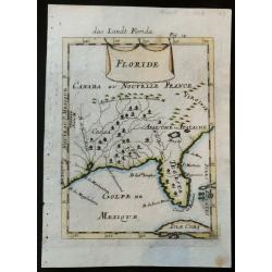
Floride
Rare 17the century copper engraved map of Florida from Allain Manesson Mallet's Description De L' Univers, Contenant Les Differents Systemes Du Monde, Les Cartes generale...
Place & Date: Paris, 1683
Selling price: $140
Sold in 2023

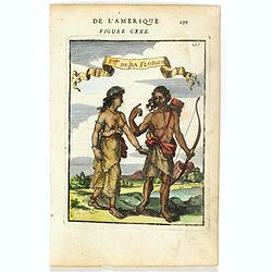
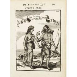
P.les de la Floride.
Attractive copper engraving, depicting a couple of native people of Florida.From the French text edition of Description d'Univers, 1683. by Allain Manneson Mallet (1630-1...
Place & Date: Paris 1683
Selling price: $50
Sold
P.les de la Floride.
Attractive copper engraving, depicting a couple of native people of Florida.
Place & Date: Paris, 1683
Selling price: $50
Sold in 2016
Sr. Augus. de Floride.
Attractive copper engraving, depicting a view of St. Augustine - the first European Settlement in North America.Shows the port, fortifications, sailing vessels and a fanc...
Place & Date: Paris, 1683
Selling price: $85
Sold in 2016
P.les de la Floride.
Attractive copper engraving, depicting a couple of native people of Florida.From the French text edition of Description d'Univers, 1683. by Allain Manneson Mallet (1630-1...
Place & Date: Paris 1683
Selling price: $55
Sold
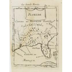
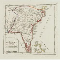
Floride.
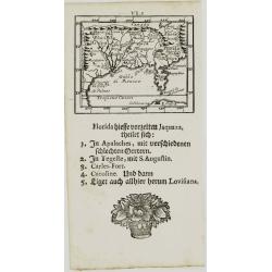
A charming late 17th century French map of Florida, Virginia, Louisiana. Tegesta is the name given to the Florida peninsula.The map has little detail, Virginia is above t...
Place & Date: Franckfurt 1684
Selling price: $200
Sold
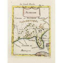
Floride. / Das Landt Florida.
A charming late 17th century French map of Florida, Virginia, Louisiana. Tegesta is the name given to the Florida peninsula.The map has little detail, Virginia is above t...
Place & Date: Frankfurt, 1684
Selling price: $110
Sold in 2008
![[Florida]](/uploads/cache/40498-250x250.jpg)
[Florida]
A rare regional American map, published by Johann Ulrich Muller. A highly coveted and most collectable miniature map of Florida, the Gulf Coast, Texas, the Mississippi Va...
Place & Date: Ulm, 1692
Selling price: $250
Sold in 2017
Florida.
A rare miniature map of North America, Florida, Gulf Coast, Texas, the Mississippi Valley and the Mid-Atlantic, with a letterpress text in German. Second state.From Johan...
Place & Date: Frankfurt, 1702
![Le Vieux Mexique ou NOUVELLE ESPAGNE avec les costes DE LA FLORIDE.[1st edition]](/uploads/cache/83258-250x250.jpg)
Le Vieux Mexique ou NOUVELLE ESPAGNE avec les costes DE LA FLORIDE.[1st edition]
The first edition of this interesting regional map of Florida, Texas, the Gulf Coast, the Southwest, Mexico and Central America, from the first edition of De Fer's Atlas ...
Place & Date: Paris, 1702
Selling price: $350
Sold in 2020
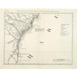
T Amerikaans Gewest van Florida Door Ferdinand de Soto.
A scarce early 18th century Van Der Aa map of Florida with enormous boundaries covering all of southeastern America from Texas to Lake Erie. A decorative cartouche shows ...
Place & Date: Leiden, 1707
Selling price: $320
Sold in 2017
Zee en Land-Togten der Franszen Gedaan na, en in' t Americaans Gewest van Florida door Ioh. Pontius Ontdekt.
Pieter van der Aa was a prolific publisher. He published a.o. ' Naaukeurige versameling der gedenkwaardigste zee- en land-reysen', a series of accounts of voyages (1706-0...
Place & Date: Leiden, 1707
Selling price: $850
Sold
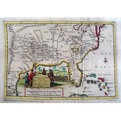
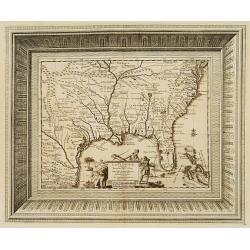
Nouvelle Carte Marine de Toute les Cotes de l´Amerique ... / Nieuwe grote en zeer curieuze Paskaart van Geheel WestIndien ...
Large size sea chart of the Caribbean and surrounding coasts, by Gerard van Keulen, son of Johannes Van Keulen. A rare map since these larger-sized sheets were never publ...
Place & Date: 1728
Selling price: $3300
Sold in 2022
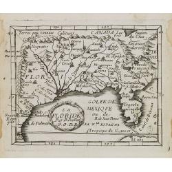
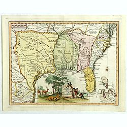
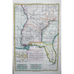
La Floride, suivant les nouvelles observations?
This splendid map of the southern United States was based on Delisle's influential Carte du Mexique de la Floride.. of 1703. The map is filled with details of early colon...
Place & Date: Amsterdam 1729
Selling price: $500
Sold
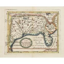
Carta geographica della florida nelp americ settentrionale.
Map taken from "Atlante Novissimo", published by Giambattista Albrizzi around 1740. Based on Delisle, the map covers the region from Filadelfia south to the Bah...
Place & Date: Venise, 1740
Selling price: $750
Sold in 2018
La Floride divisee en Floride et Caroline.
Nice small map representing the southeastern part of the United States, centred on Florida. It shows the Bahamas at the bottom.Number 93 outside border top right. Mary Sp...
Place & Date: Paris, later than 1749
Selling price: $260
Sold
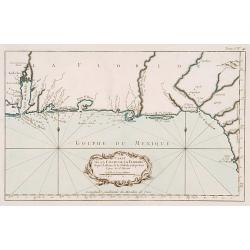
Carte de la coste de la Floride..
Shows the Florida panhandle to Mobile Bay. Little interior data was known. The only issue of this version of Bellin's map, slightly larger than the common version. From B...
Place & Date: Paris 1764
Selling price: $525
Sold
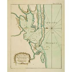
Plan de la Baye de Pensacola dans la Floride.
This chart shows the territories of the inlet of Pensacola in Florida The only issue of this version of Bellin's map, slightly larger than the common version. Depths show...
Place & Date: Paris 1764
Selling price: $125
Sold
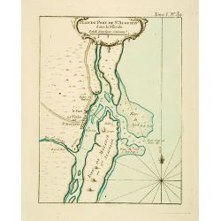
Plan du Port de St Augustin dans la Floride.
This chart shows a plan of the Port of St. Augustine in Florida.The only issue of this version of Bellin's map, slightly larger than the common version. Depths shown by s...
Place & Date: Paris 1764
Selling price: $185
Sold
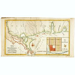
A Map of Part of West Florida from Pensacola to the Mouth of the Iberville River, with a view to shew the proper spot for a Settlement on the Mississipi.
Uncommon map of the Mississippi delta and coastal regions of Mississippi, Alabama and the panhandle of Florida., from the February 1772 edition of Gentleman's Magazine, w...
Place & Date: London 1772
Selling price: $200
Sold in 2017
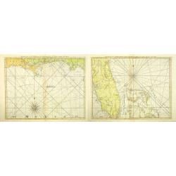
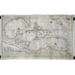
The Coast of West Florida and Louisiana. (together with) The Peninsula and Gulf of Florida or Channel of Bahama with the Bahama Islands.
Two nautical charts showing of the coast of West Florida and Louisiana, together with the Peninsula and Gulf of Florida or Channel of Bahama with the Bahamas Islands. Dep...
Place & Date: London, Sayer and Bennett, 1775
Selling price: $1700
Sold in 2012
Parte Orientale della Florida, della Giorgia, e Carolina Meridionale.
Attractive map covering the coast from S.Augustine till Long Bay, including Jacksonville, Savannah. From Zatta's Atlante Novissimo.
Place & Date: Venice, 1778
Selling price: $145
Sold in 2011
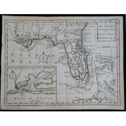
A Map of the New Governments of East & West Florida
Scarce early map of East & West Florida, shortly after the end of the French & Indian War.
Place & Date: London, 1780
Selling price: $200
Sold in 2023
Carte de la Louisiane et de la Floride
Interesting map of the Southeast and the Mississippi River Valley. The map extends from Charleston, South Carolina west to include New Orleans and north well into Illinoi...
Place & Date: Paris, c1780
Selling price: $180
Sold in 2013
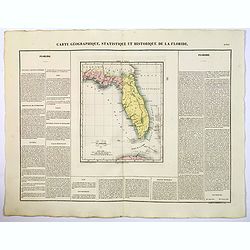
Carte Geographique, Statistique ey Historique de la Floride.
A lovely, detailed map of Florida, from Buchon's, Atlas Gégraphique Statistique, historique et chronologique des deux Ameriques et des isles adjacentes traduit de l'atla...
Place & Date: Paris, 1825
Selling price: $150
Sold in 2022
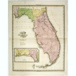
Map of Florida by H.S. Tanner. Improved to 1825
A very fine example of the revised 1825 issue of Henry Schenk Tanner's important map of Florida, with significant changes to the mapping. The second edition of the map sh...
Place & Date: Philadelphia, Henry Tanner, 1825
Selling price: $1800
Sold in 2014
![[ Florida Indian dances ].](/uploads/cache/27560-250x250.jpg)
[ Florida Indian dances ].
Aquatint depicting Florida Indian dances engraved by Gallina. Plate N°55.From Giulio Ferrario's work Le Costume Ancien et Moderne ou Histoire du gouvernement, de la mili...
Place & Date: Milan, 1827
Selling price: $240
Sold in 2013
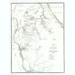
A Map of the Seat of War in Florida 1836.
This is the first map by Major Gen. W. Scott to highlight the progress of the Native American Seminole Wars. The map shows most of northern Florida from Charlotte Harbour...
Place & Date: United States, ca 1836
Selling price: $95
Sold in 2018
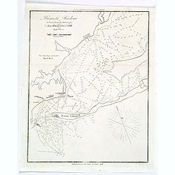
Pensacola Harbour.
A small naval chart of Pensacola Harbour and surrounds in Florida, reduced from a survey of Major Kearney, U.S.T.E. It features depth soundings (measured in feet), a Ligh...
Place & Date: New York, 1847
Selling price: $4
Sold in 2019
![Map No.5 United States [Alabama, Georgia, South Carolina, Florida].](/uploads/cache/39987-250x250.jpg)
Map No.5 United States [Alabama, Georgia, South Carolina, Florida].
A pleasant map of the S.E. corner of the United States, each state colored differently. A few lines of explanation beneath the plain title.Most major towns and cities dep...
Place & Date: New York, 1847
Selling price: $50
Sold in 2017
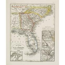
Die Staaten von N. & S. Carolina Georgia & Florida 1850.
Detailed map of Florida, North and South Carolina, with inset maps of St.Augustine, Newberne, Charleston and "Gold region von Nord -Carolina".Major ?roads? show...
Place & Date: Hildburghausen, 1852
Selling price: $80
Sold
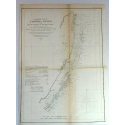
Preliminary Chart of Florida Keys from Key Biscayne to Pickles Reef
Detailed chart of Florida reefs with soundings. From a Trigonometrical Survey under the direction of A.D. Bache, Superintendent of the Survey of the coast of the United S...
Place & Date: New York, 1856
Selling price: $14
Sold in 2018
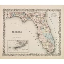
FLORIDA.
First edition. Issue with decorative borders. Fine map of Florida with smaller inset map "Plan of the Florida Keys". Of particular interest is the Arredondo Gra...
Place & Date: New York, c. 1856
Selling price: $28
Sold in 2014
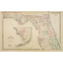
Colton's Florida.
With inset map of the southern part of Florida. Extremely detailed map (scale 1:140.000). On verso one page of text with a wealth of geographical information.
Place & Date: New York, 1868
Selling price: $100
Sold in 2009
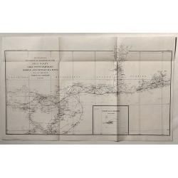
Sketch Showing Progress of Surveys on the Gulf Coast Lake Pontchartrain, Mobile and Pensacola Bays.
This is the Survey Report of 1896 by the U.S. Coast and Geodetic Department. It includes an insert of Tortugas Harbor.
Place & Date: Washington, 1896
Selling price: $19
Sold in 2020
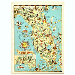
Florida.
Pictorial map of Florida, from the famous illustrator, Ruth Taylor White and published in "Our USA: A Gay Geography".Ruth Taylor White was among the most prolif...
Place & Date: Boston, Little, Brown and Company, 1935
Selling price: $90
Sold in 2017
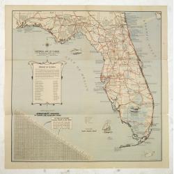
Historical map of Florida showing points of interest to visitors.
Historical map of Florida showing points of interest to visitors, issued by Florida State Department of Agriculture, in 1937 under the commission of Nathan Mayo and T.J.B...
Place & Date: Jacksonville, the Drew Press, 1937
Selling price: $105
Sold in 2012
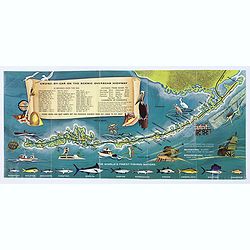
Florida Keys & Key West. . .
A folding map (brochure) advertising the many attractions of the Florida Keys and Key West. Map. The map is illustrated by a number of cartoonish vignettes of local wildl...
Place & Date: Miami, aftrer 1960
Selling price: $50
Sold in 2020
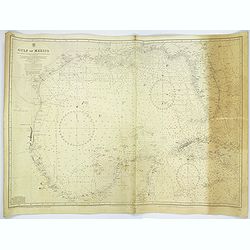
Gulf of Mexico.
A large sea chart of the Gulf of Mexico 'from Admiralty Charts and US Government charts, corrected to 1966'. (In fact there are corrections up until 1977).Chart extent is...
Place & Date: London, 1882 corrected to 1966
Selling price: $95
Sold in 2017
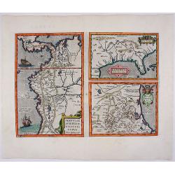
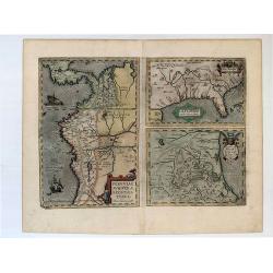
![La Florida [with] Guastecan [with] Peruviae Auriferae Regionis Typus.](/uploads/cache/83483-250x250.jpg)
La Florida [with] Guastecan [with] Peruviae Auriferae Regionis Typus.
Three-in-one map from a Ortelius' "Theatrum Orbis Terrarum" Atlas published in Antwerp 1572/1598, Dutch language edition. Showing: Florida and the south, after...
Place & Date: Antwerp, 1572/98
Selling price: $600
Sold in 2019