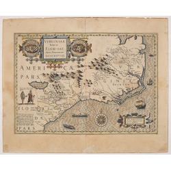
Browse Listings in Antique Maps > America > North America
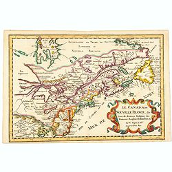
Le Canada, ou Nouvelle France, &c, tiree de diverses Relations des Francois, Anglois, Hollandois, &c. . .
A fine smaller map of the north eastern US seaboard, extending to the Great Lakes (shown as open-ended) and beyond into 'Upper Canada' by Nicolas Sanson, and originally f...
Place & Date: Utrecht, 1665
Selling price: $420
Sold in 2021
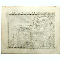
Terra Nueva
Gastaldi's map of Eastern USA from Giacomo Gastaldi's Atlas of 1548 which has been called the most comprehensive atlas, produced between Martin Waldseemüller's Geographi...
Place & Date: Venice, 1548
Selling price: $3400
Sold in 2023
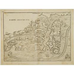
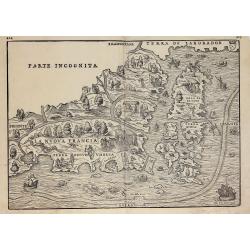
Nova Francia.
RARE FIRST STATE of the woodcut map of the Atlantic coastline from New York to Labrador. Manhattan as the peninsula "Angouleme", named after King Francis I, Duk...
Place & Date: Venice 1556
Selling price: $5100
Sold
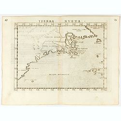
Tierra Nueva.
Uncommon first edition of this early map of the east coast is an enlarged version of Giacomo Gastaldi map published in 1548. Nomenclature and cartography are unchanged, w...
- $1000 / ≈ €914.79
Place & Date: Venice, 1561
La Nuova Francia.
Second state of the woodcut map of the Atlantic coastline from New York to Labrador. Manhattan as the peninsula "Angouleme", named after King Francis I, Duke of...
Place & Date: Venice, 1565
Selling price: $2800
Sold in 2012
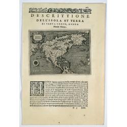
Descrittione dell' isola et terra di Santa Croce, overo Mondo Nuovo.
Porcacchi's map of North America, set in a page of text From "L'Isole piu famoso del mondo”. This is the second earliest obtainable map of North America, preceded ...
Place & Date: Venice, 1572-1585
Selling price: $550
Sold in 2019
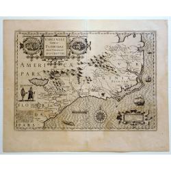
Americae pars, Nunc Virginia dicta, primum ab Anglis. . .
John White's map, elegantly designed and superbly engraved, revolutionized geographic knowledge of the region. Although White left the Chesapeake poorly explored, much of...
Place & Date: Frankfurt, 1590
Selling price: $12010
Sold

Wie die Weiber von Dafamonguepeuc.
Engraving depicting a native American woman of Dasamonguepeuc carrying a child, from Theodorus De Bry's Les Grands Voyages.
Place & Date: Frankfurt, 1590
Selling price: $90
Sold in 2013
![[The Englishmen's arrival in Virginia with Roanoke Colony - Carolina Coastline] No title.](/uploads/cache/42117-250x250.jpg)
[The Englishmen's arrival in Virginia with Roanoke Colony - Carolina Coastline] No title.
Map showing the coast of Virginia with many islands just off the mainland, two Native territories, Secotan and Weapemeoc, and the Native community of Roanoak on an island...
Place & Date: Frankfurt, c. 1590
Selling price: $285
Sold in 2018
Americae pars, Nunc Virginia dicta, primum ab Anglis. . .
John White's map, elegantly designed and superbly engraved, revolutionized geographic knowledge of the region. Although White left the Chesapeake poorly explored, much of...
Place & Date: Frankfurt, 1590
Selling price: $8100
Sold in 2019
![La Florida [with] Guastecan](/uploads/cache/florida_01-250x250.jpg)
La Florida [with] Guastecan
A fine, old-colored example of Abraham Ortelius’ seminal map of Florida and the North American South. Ortelius’ map La Florida was the foundation for cartography ...
Place & Date: Antwerp, 1590
Selling price: $650
Sold in 2023
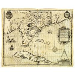
Floridae Americae Provinciae recens & exactissima descriptio . . .
A superb map of the Eastern Seaboard from Cape Lookout to Florida, with Cuba and the Bahamas, by the official artist of the second French Huguenot expedition to their col...
Place & Date: Frankfurt, 1591
Selling price: $12750
Sold in 2012
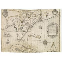
Floridae Americae Provinciae recens & exactissima descriptio . . .
A superb map of the Eastern Seaboard from Cape Lookout to Florida, with Cuba and the Bahamas, by the official artist of the second French Huguenot expedition to their col...
Place & Date: Frankfurt, 1591
Selling price: $1500
Sold in 2014

French battle with Florida Indians, 1591
Exciting de Bry engraving from 'der ander Theil der newlich erfundenen Landtschafft Americae' showing French soldiers aiding native North Americans in a war against a riv...
Place & Date: Frankfurt, c.1591
Selling price: $225
Sold in 2014
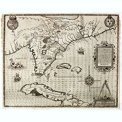
Floridae Americae Provinciae recens & exactissima descriptio . . .
A superb map of the Eastern Seaboard from Cape Lookout to Florida, with Cuba and the Bahamas, by the official artist of the second French Huguenot expedition to their col...
Place & Date: Frankfurt, 1591
Selling price: $5700
Sold in 2019
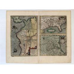
La Florida/ Peruviae Auriferae regionis Typus/ Guastecan.
The Chaves map of Florida is a prime example of an explorer's map since it records the recent discoveries of Cabeza de Vaca, De Soto, and Moscoso. The map revealed little...
Place & Date: Antwerp, 1592
Selling price: $1200
Sold in 2016
Pervviae Avrifer Regionis Typus, La Florida, Guastecan
This important work from Ortelius’ atlas Theatrum Orbis Terrarum features maps which were among the very few to be based on Spanish sources, all of which draw from the ...
Place & Date: Antwerp, 1592
Quivirae Regnv cum alijs versus Borea.
Extraordinarily rare map, the first published map devoted to the west and north-west coasts of North America.The map not only conveys the early cartographic view of the N...
Place & Date: Antwerp 1593
Selling price: $11075
Sold
![[The French left in Fort Charles suffer the scarcity of provisions.]](/uploads/cache/48529-250x250.jpg)
[The French left in Fort Charles suffer the scarcity of provisions.]
An Indian town visited by the French of Charlesfort in search for food. After a drawing by LeMoyne. Charlesfort-Santa Elena is on what is now Parris Island, South Carolin...
- $400 / ≈ €365.91
Place & Date: Frankfurt, 1594
![Arcis Carolinae delineatio [Jacksonville]](/uploads/cache/48530-250x250.jpg)
Arcis Carolinae delineatio [Jacksonville]
Depicting Fort Caroline in Jacksonville, Florida. A French expedition, organized by Protestant leader Admiral Gaspard de Coligny and led by the French Explorer Jean Ribau...
- $400 / ≈ €365.91
Place & Date: Frankfurt, 1594
Cacodemon attacking the savages.
Cacodemon ("evil spirit") attacking the savages. Read more about "Les Grand Voyages" by Theodore De Bry [+]
- $200 / ≈ €182.96
Place & Date: Frankfurt, 1594
La Florida_Guastecan_Peruviae Avriferae Regionis Typus.
The most important map (La Florida) is the first printed map of the southeastern region of the United States. This influential map provided the foundation cartography for...
Place & Date: 1595
Selling price: $800
Sold in 2017
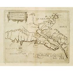
Granata Nova et California.
Very rare sixteenth century map: the second printed map devoted to the California peninsula and the south west of present day United States. A reduced version of the Corn...
Place & Date: Cologne 1598
Selling price: $1600
Sold
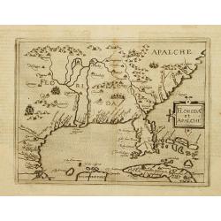
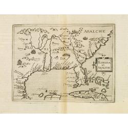
Florida et Apalche.
Very rare sixteenth century map: drawn from the Abraham Ortelius -Gerónimo de Chaves map entitled La Florida, published in 1584. However, here Metellus expands the area ...
Place & Date: Cologne 1598
Selling price: $3125
Sold
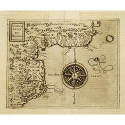
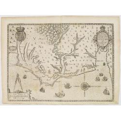
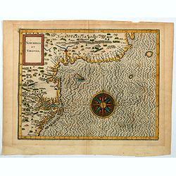
Norumbega et Virginia.
Rare sixteenth century map: It shows the east coast of North America from the Outer Banks of present day Carolina to Canada is depicted at a period just before a number o...
Place & Date: Cologne 1598
Selling price: $3000
Sold
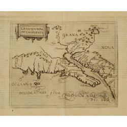
Granata Nova et California.
Very rare sixteenth century map: the second printed map devoted to the California peninsula and the south west of present day United States. A reduced version of the Corn...
Place & Date: Cologne 1598
Selling price: $1900
Sold
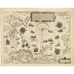
Deliniatio cartae trium navigationum per Batavos..
A major landmark in Arctic cartography incorporating recent voyages including Barents' third voyage to this region, made in 1596-7. A derivative of Willem Barentsz's map ...
Place & Date: Frankfurt 1599
Selling price: $2150
Sold

Franciscus Draco cum in locum quendam venis set, à Rege istius regionis convenitur.
This famous and desirable scene was engraved by de Bry native Americans approaching European soldiers and offer gifts. A group of native Americans sit around a fire in a ...
Place & Date: Frankfurt, Matthaeus Becker, 1599
Selling price: $300
Sold in 2014
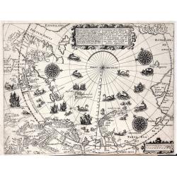
Deliniatio cartae trium navigationum per Batavos. . .
A major landmark in Arctic cartography incorporating recent voyages including Barents' third voyage to this region, made in 1596-7. A derivative of Willem Barentsz's map ...
Place & Date: Frankfurt, 1599
Selling price: $1900
Sold in 2012
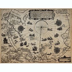
Deliniatio cartae trium navigationum per Batavos..
A major landmark in Arctic cartography incorporating recent voyages including Barents' third voyage to this region, made in 1596-7. A derivative of Willem Barentsz's map ...
Place & Date: Frankfurt, 1599
Selling price: $2500
Sold in 2017
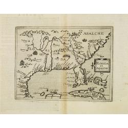
Florida et Apalache.
Very rare map of Florida, including parts of Cuba and the east coast north to the area of the Outer Banks of Carolina. The map is a reduced version of Cornelis Wytfliet m...
Place & Date: Cologne 1600
Selling price: $2000
Sold
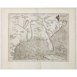
Florida et Apalche.
Very rare map of Florida, including parts of Cuba and the east coast north to the area of the Outer Banks of Carolina. The map is a reduced version of Cornelis Wytfliet m...
Place & Date: Cologne, 1600
Selling price: $3300
Sold in 2013
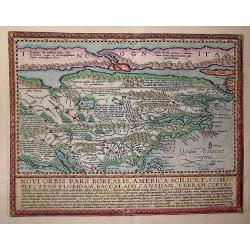
Novi Orbis Pars America. . .
Published in Cologne in 1600 this map is from 'Geographisch Handtbuch' with German text on the verso.Quad's map of North America is derived from De Jode and is a beautifu...
Place & Date: Cologne, 1600
Selling price: $2300
Sold in 2013
Florida et Apalche.
Wyfliet's map is one of the earliest to focus on the Southeast and to name "Florida", showing part of Texas, Mexico, Cuba, the Bahamas and the Gulf of Mexico.Dr...
Place & Date: Louvain, 1597-1600
Selling price: $2500
Sold in 2020
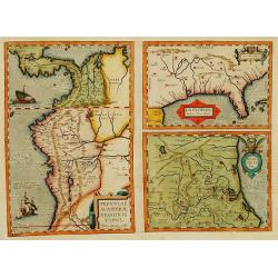
Peruviae Auriferae.. La Florida.. Guatecan..
Didacus Mendezius' is mentioned on the map as the author of the map, however this person is unknown in cartographical history. Possibly, it derives from Don Diego Hurtado...
Place & Date: Antwerp 1584-1603
Selling price: $1900
Sold
Peruviae Auriferae Regionis Typus. - La Florida - Guastecan.
[3 maps: Florida, Peru and Mexico.] "The Florida map is one of the very few maps printed in the sixteenth century that was based upon original Spanish sources. They ...
Place & Date: Antwerp, 1603
Selling price: $780
Sold in 2019
![Tartariae Sive Magni Chami Regni typus. [Alaska and N.America West coast]](/uploads/cache/84445-250x250.jpg)
Tartariae Sive Magni Chami Regni typus. [Alaska and N.America West coast]
Important Map of Asia and North America Included in the World’s First Modern Atlas. It is the earliest obtainable map to name California and is one of the first to incl...
Place & Date: Antwerp, 1603
Selling price: $700
Sold in 2021
![[Native Virginian women sitting around a fire].](/uploads/cache/39419-250x250.jpg)
[Native Virginian women sitting around a fire].
A print of (mostly) native Virginian women sitting around a large campfire, one with plenty of flame and smoke.Theodore De Bry (1528-1598), was born in Liege in modern da...
Place & Date: Frankfurt, 1607
Selling price: $130
Sold in 2018
![[The town of Pomeiock].](/uploads/cache/39420-250x250.jpg)
[The town of Pomeiock].
Pomeiock was a village with a strong palisade all round, and a very narrow entrance, which was typical of that region.
Place & Date: Frankfurt, 1607
Selling price: $400
Sold in 2017
![[The town of Pomeiock].](/uploads/cache/42276-250x250.jpg)
[The town of Pomeiock].
Pomeiock was a village with a strong palisade all round, and a very narrow entrance, which was typical of that region. Inside were a few houses in which only the chief an...
Place & Date: Frankfurt, 1607
Selling price: $400
Sold in 2018
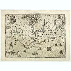
Norumbega et Virginia.
An important map that shows the east coast of North America from the Outer Banks of present day Carolina and on up to Canada. Chesapeake Bay is called "Chesipooc Sin...
Place & Date: Douai, 1607
Selling price: $2050
Sold in 2020
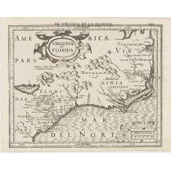
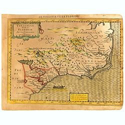
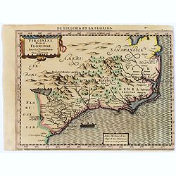
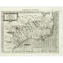
Virginia et Florida.
Excellent example of Mercator's miniature map of Colonial America, south to named St. Augustine, north past Chesapeake Bay. Early reference to 'Apalacci' Mountains, showi...
Place & Date: Amsterdam, 1608
Selling price: $500
Sold in 2013
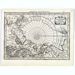
Polus Arcticus cum vicinis regionibus.
Map of the North Pole regions from the 1608 second edition of Jodocus Hondius' Atlas Minor.A reduction of the 1606 Mercator-Hondius folio map (which is a later state of t...
Place & Date: Amsterdam, 1608
Selling price: $500
Sold in 2012
Virginiae Item et Floridae Americae Provinciarum.nova Descriptio.
An attractive, detailed and early map of the Southeast from the rare Cloppenburg edition slightly larger format and more scarce edition of the Mercator/Hondius "Atla...
Place & Date: Amsterdam, Cloppenburgh, 1608
Selling price: $300
Sold in 2016
Tartariae sive magni regni...
An attractive old color example of this important map of Tartary, Japan, and the west coast of North America, from Ortelius' Theatrum Orbis Terarrum, the first modern at...
Place & Date: Amsterdam, 1608
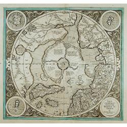
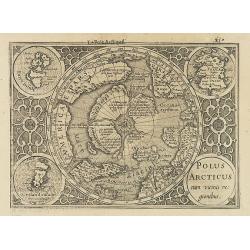
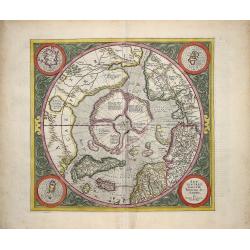
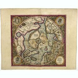
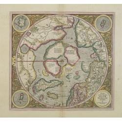
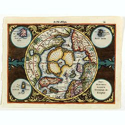
SEPTENTRIONALIUM Terrarum descriptio. Per Gerardum Mercatore
State 2. This is the first map devoted to the Arctic, a hemispherical one on a North Polar projection with an attractive floral design surrounding it. In the corners are ...
Place & Date: Amsterdam 1609
Selling price: $1325
Sold
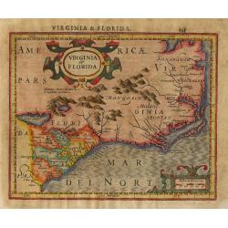
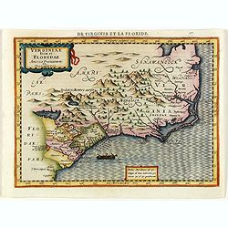
Virginia et Florida
Nice small map based on the Hondius' folio map of the same name. Based on John White's Virginia and Jacques le Moyne's Florida as interpreted by Theodore de Bry. Numerous...
Place & Date: Amsterdam, 1609
Selling price: $300
Sold in 2011
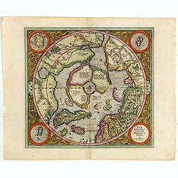
SEPTENTRIONALIUM Terrarum descriptio. Per Gerardum Mercatore.
State 2. This is the first map devoted to the Arctic, a hemispherical one on a North Polar projection with an attractive floral design surrounding it. In the corners are ...
Place & Date: Amsterdam, 1609
Selling price: $2450
Sold in 2013
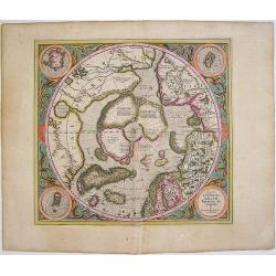
Septentrionalium Terrarum descriptio. Per Gerardum Mercatorem Cum Privilegio.
State 2. This is the first map devoted to the Arctic, a hemispherical one on a North Polar projection with an attractive floral design surrounding it. In the corners are ...
Place & Date: Amsterdam, 1609
Selling price: $2000
Sold in 2015
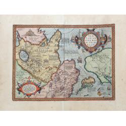
Tartariae sive Magni Chami Regni Typus.
Tartariae sive Magni Chami Regni Typus. Map of Mongolia, also showing the northwest coast of North America. Abraham Ortelius(1527-98), Dutch cartographer and publishe...
Place & Date: Antwerp, Robert Bruneau, 1609
Selling price: $500
Sold in 2021
Septentrionalium Terrarum descriptio
This influential map was the first separately printed map devoted to the Arctic. The hemisphere is surrounded by a floral design with four roundels in each corner. These ...
Place & Date: Amsterdam, 1611
Selling price: $1150
Sold in 2011
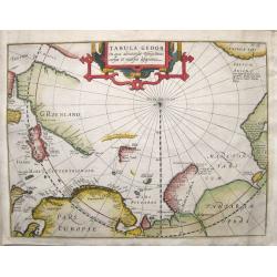
Tabula Geogr. in qua admirandae navigationis cursus et recursus designatur.
First state of a very early and scarce map of the North Pole and Arctic regions showing recent discoveries including the voyage of Jan Willem Barentsz on his quest to fin...
Place & Date: Amsterdam, 1611
Selling price: $850
Sold in 2016
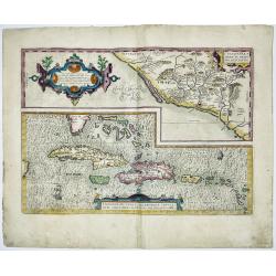
CULIACANAE,A MERICAE REGIO NIS, DESCRIPTIO - Hispaniolae, Cubae, Aliarumique Insularum Circumiacientium Delineatio
CULIACANAE, A MERICAE REGIO NIS, DESCRIPTIO - Hispaniolae, Cubae, Aliarumique Insularum Circumiacientium Delineatio.Antique map of the Caribbean. Two maps on one sheet: ...
Place & Date: Antwerp, 1603-1612
Selling price: $400
Sold in 2023
Tartariae sive Magni Chami Imperium.
This is a very early depiction of the northern Pacific, with the first mapping of Northwest Coast of America and probably the first map to name California 'C. Califormio...
- $2500 / ≈ €2286.97
Place & Date: Antwerp, c. 1608-1612
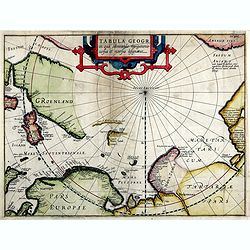
Tabula Geogr. In qua admirandae navigatonis..
A finely engraved map by Jodocus Hondius with coastline details of northern Europe, Greenland, Frisland, Strait Anian with America pars. With the track of a Willem Barent...
Place & Date: Amsterdam, 1614
Selling price: $740
Sold in 2019
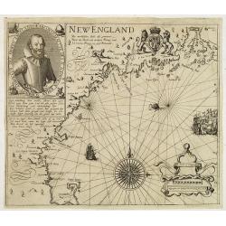
New England/ Die mercklichsten dheile. .
Hulsius used the first state of Smith's New England map published the previous year in London. The most noticeable differences, however, are the lack of any imprints lowe...
Place & Date: Frankfurt ,1617
Selling price: $8100
Sold in 2012
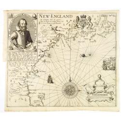
Die Mercklichsten Dheile, also Genennet durch den Durchl: und Mechtigen Prinzen und H.H. Carolus, Prinzen von Gross Britannien.
Hulsius used the first state of Smith's New England map published the previous year in London. The most noticeable differences, however, are the lack of any imprints lowe...
Place & Date: Frankfurt, 1617
Selling price: $10000
Sold
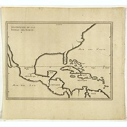
Descripcion De Las Yndias Del Norte.
Map of the Southern United States, Mexico, Central American and the Caribbean, from his Description des Indes Occidentales Qu'on appelle aujourdhuy Le Nouveau Monde. . fi...
Place & Date: Amsterdam, Michel Colin, 1622
Selling price: $700
Sold in 2017
SEPTENTRIONALIUM Terrarum descriptio. Per Gerardum Mercatore
State 2. This is the first map devoted to the Arctic, a hemispherical one on a North Polar projection with an attractive floral design surrounding it. In the corners are ...
Place & Date: Amsterdam, 1623
Selling price: $2100
Sold in 2016
SEPTENTRIONALIUM Terrarum descriptio. Per Gerardum Mercatore
State 2. This is the first map devoted to the Arctic, a hemispherical one on a North Polar projection with an attractive floral design surrounding it. In the corners are ...
Place & Date: Amsterdam, 1623
Selling price: $1500
Sold in 2019
![[Unmounted gores from a very rare Dutch Globe]](/uploads/cache/46309-250x250.jpg)
[Unmounted gores from a very rare Dutch Globe]
These rare gores are very possibly the only surviving examples from a 17 inch (44cm) diameter globe by Hondius and Janssonius. It is believed that only four of five examp...
Place & Date: Amsterdam, ca 1623
Selling price: $7600
Sold in 2020
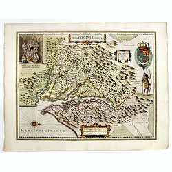
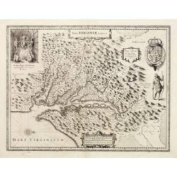
Virginiae item et Floridae Americae provinciarum nova descriptio
"Virginiae item et Floridae Americae provinciarum nova descriptio" is a map created by Dutch cartographer Gerard Mercator and Jodocus Hondius in 1606. It is sig...
Place & Date: Amsterdam 1623
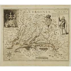
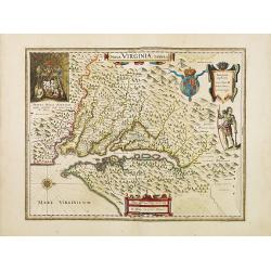
Virginia.
One of the most important printed maps of America ever produced and certainly one of the greatest influence. It became the prototype for the area for half a century. Firs...
Place & Date: Frankfurt 1627
Selling price: $4600
Sold
Septentrionalium Terrarum decsript.
A good example of Mercator-Jansson's small map of the North Polar regions.The map is extended to 60 degrees, to show the recent explorations in search of the North West a...
Place & Date: Amsterdam, ca. 1628
Selling price: $195
Sold in 2017
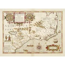
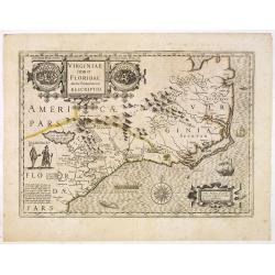
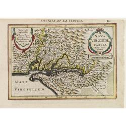
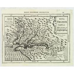
Nova Virginiae Tabula.
The map is based on the first state of Smith's map, 1612, and is slightly larger and more expertly engraved. In 1629 the Hondius plate was purchased by Blaeu who deleted ...
Place & Date: Amsterdam 1618-1629
Selling price: $2300
Sold

Virginiae item et Floridae.
Cummings describes it as one of the most beautifully executed maps ever made of the Southeast. In detail and in general conception it surpasses all earlier maps of the re...
Place & Date: Amsterdam, 1630
Selling price: $2500
Sold in 2013
Virginiae item et Floridae.
"Cummings describes it as ""one of the most beautifully executed maps ever made of the Southeast. In detail and in general conception it surpasses all earl...
Place & Date: Amsterdam 1630
Selling price: $2400
Sold
Septentrionalium Terrarum descriptio.
The classic map of the Arctic region, representing the late Medieval concept of four islands surrounding a centralized whirlpool. This polar depiction was an expansion of...
Place & Date: Amsterdam, 1630
Selling price: $1600
Sold in 2009
Virginiae item et Floridae..
Cummings describes it as one of the most beautifully executed maps ever made of the Southeast. In detail and in general conception it surpasses all earlier maps of the re...
Place & Date: Amsterdam, 1630
Selling price: $1050
Sold in 2016
Virginiae item et Floridae..
Cummings describes it as one of the most beautifully executed maps ever made of the Southeast. In detail and in general conception it surpasses all earlier maps of the re...
Place & Date: Amsterdam, 1630
Selling price: $900
Sold in 2014
Nova Virginiae Tabula.
The map is based on the first state of Smith's map, 1612, and is slightly larger and more expertly engraved.The map is, in part, famous for its depiction, upper left, of ...
Place & Date: Amsterdam, 1630
Selling price: $1200
Sold in 2016
Virginiae item et Floridae.
From the rare French text edition of Mercator's Atlas Minor. From the first of the so-called Cloppenburg edition with new engraved maps in a larger format. The map extend...
Place & Date: Amsterdam, 1630
Selling price: $240
Sold in 2017
Virginiae item et Floridae Americae Provinciarum nova Descriptio.
Map of the Carolinas and parts of Virginia and Georgia. The map extends from St. Augustine in the south to just north of Chesepioock Sinus in the north and to the Allegha...
Place & Date: Amsterdam, 1630
Selling price: $800
Sold in 2022
Septentrionalium Terrarum descriptio.
Artic pole map from the rare Cloppenburg edition slightly larger format and more scarce edition of the Mercator/Hondius "Atlas Minor". The classic map of the Ar...
Place & Date: Amsterdam, 1630
Selling price: $230
Sold in 2020
Nova Virginiae Tabula.
Janssonius' derivative of John Smith's landmark map of the Chesapeake of which only three other copies have been recorded (Verner). The map is the only regional map of Am...
Place & Date: Amsterdam 1628-1631
Selling price: $500
Sold
Nova Virginiae Tabula
NO TEXT ON VERSO: From the rare Atlantis Appendix of 1630 and 1631.One of the most important maps of the Chesapeake Bay region, credited with disseminating knowledge of t...
Place & Date: Amsterdam ca. 1630-1631
Selling price: $2050
Sold
Virginiae Item et Floridae Americae Provinciarum.nova Descriptio.
An attractive, detailed and early map of the Southeast from the rare Cloppenburg edition slightly larger format and more scarce edition of the Mercator/Hondius "Atla...
Place & Date: Amsterdam, 1632
Selling price: $300
Sold in 2012
Nova Virginiae Tabula. . .
An attractive, detailed and early map of the Chesapeake region from the rare Cloppenburg edition slightly larger format and more scarce edition of the Mercator/Hondius &q...
Place & Date: Amsterdam, 1632
Selling price: $300
Sold in 2012
![[Drake capturing of St. Augustine in Florida].](/uploads/cache/39913-250x250.jpg)
[Drake capturing of St. Augustine in Florida].
Scarce print with a German text sheet showing Drake's men overrunning the settlement of St. Augustine. Fleet is anchored in the bay. From de Bry's "Great American Vo...
Place & Date: Frankfurt, M. Merian, 1633
Selling price: $210
Sold in 2017
![[The French reach Port Royal].](/uploads/cache/39919-250x250.jpg)
[The French reach Port Royal].
Scarce print with a German text sheet. When the French arrived, they called it Portuus Regalis or Port Royal because of its size and beauty. There they brought in the sai...
Place & Date: Frankfurt, M.Merian, 1633
Selling price: $220
Sold in 2018