Browse Listings in Antique Maps > World Maps
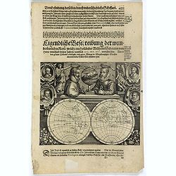
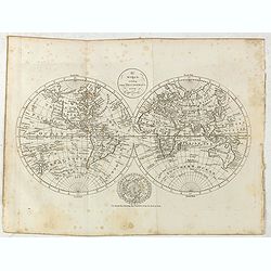
Description de nouveau pasage vers le zud.... together with an untitled map of Port Desire (today's Puerto Deseado, Argentina)
Rare double hemispherical world map showing the track round the world by Le Maire and Schouten in 1615-1617. Continents are marked in outline and no southern regions are ...
Starting Bid: $800
BidAsk spread: $1000 - $1500
Maker / Publisher: GOTTFRIED, J.L.Place & Date: Frankfurt, M.Merian, 1631
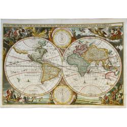
ORBIS TERRARUM TYPUS DE INTEGRO IN PLURIMIS EMENDATUS, AUCTUS, ET ICUNCULIS ILLUSTRATUS
Very rare world map from an old Dutch bible. Verso: blank. The map has the same title and apparently similar decorations in the four corners as the famous Visscher-Ber...
Starting Bid: $1400
BidAsk spread: $1750 - $2250
Maker / Publisher: Dancker DanckertsPlace & Date: Amsterdam, 1648
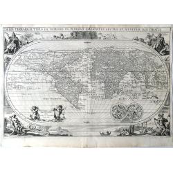
ORBIS TERRARUM TYPUS DE INTEGRO IN PLURIMIS EMENDATUS . AUCTUS ET ICUNCULUS ILLUSTRATUS
World Map of the utmost rarity by Dancker Danckerts, from 1658, and found in a scarce Gorinchem Bible published in 1665. This is the first time we are offering this map...
Starting Bid: $5000
BidAsk spread: $6500 - $8000
Maker / Publisher: Danckerts, DanckerPlace & Date: Amsterdam, 1658
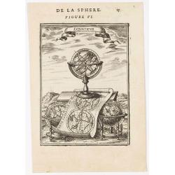
Equateur.
Appealing print centered on an armillary sphere. The latter sits atop a map of the world which clearly shows California as an island. In addition to this curious feature,...
Starting Bid: $50
BidAsk spread: $75 - $200
Maker / Publisher: MALLET, A.M.Place & Date: Paris, 1683
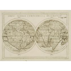
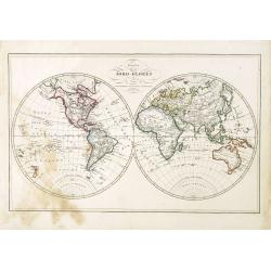
Orbis Terrae compendiosa descriptio.
Modern world map by Rosaccio, consisting of two hemispheres enclosed within a plain border. The engraving is sharp and neat, and is a skilful reduction of Rumold Mercator...
Starting Bid: $400
BidAsk spread: $480 - $1000
Maker / Publisher: ROSACCIO / SESSA heirs.Place & Date: Venise, 1598/1713
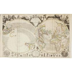
A new and correct map of the world.
The early eighteenth century was one of the most important periods for English cartography. One of the period's most intriguing world maps is this large-scale map which o...
- Highest Bid:
- $7000 / ≈ €6403.51
BidAsk spread: $8000 - $12000
Maker / Publisher: WILLDEY, G./ PRICE, Ch.Place & Date: London 1714
1 bid
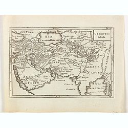
Orientis tabula.
A detailed map of the ancient 'Orient' as known to classical geographers, stretching from the Arabian peninsula to the Indian subcontinent, highly likely to be engraved b...
Starting Bid: $35
BidAsk spread: $40 - $75
Maker / Publisher: SENEX, JOHN after Cellarius.Place & Date: London, ca 1730
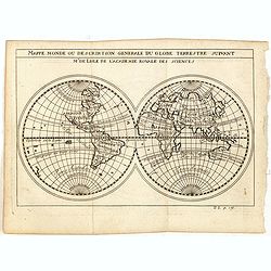
Mappe monde ou description generale du globe terrestre suivant Mr.de Lisle de l'academie Royale des sciences.
Scarce small map of Europe based on cartography of Guillaume Delisle (. Published in "Nouveau traité de geographie par M**** ", published by La veuve Lottin &a...
Starting Bid: $64
BidAsk spread: $80 - $200
Maker / Publisher: DELISLE, G. afterPlace & Date: Paris, 1752
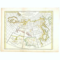
Carte des parties Nord et Est de L'Asie. . .
Five maps on one sheet, showing the Northern Russian territories in Europe and Asia, including the western coastline from Siberia, with Japan and Korea with the island of...
Starting Bid: $40
BidAsk spread: $50 - $100
Maker / Publisher: DIDEROT, D.Place & Date: Paris, 1779
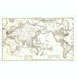
The world, including the discoveries made by Capt. Cook.
Uncommon double-hemisphere world map depicting the voyages and discoveries of Captain James Cook. There are numerous notations throughout and the tracks of Cook's three v...
Starting Bid: $480
BidAsk spread: $580 - $1000
Maker / Publisher: BOWEN, T.Place & Date: London, 1781
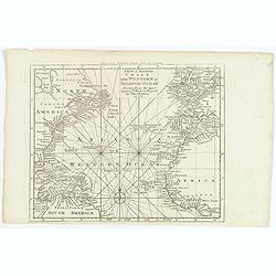
A New & Accurate Chart of the Western or Atlantic Ocean.
A map from 'Middleton's Complete System of Geography', from the Arctic Ocean in the north, south to the top of South America and across to the Slave Coast of Africa. Fro...
Starting Bid: $32
BidAsk spread: $40 - $70
Maker / Publisher: BOWEN, Thomas.Place & Date: London, 1788
Uebersichtscharte Britischen Reichs. . .British Empire
An unusual and scarce German world map depicting the British colonies and protected areas (the fully shaded regions). With a pair of explanatory boxes, continents, seas a...
Starting Bid: $60
BidAsk spread: $75 - $125
Maker / Publisher: HERZ, W.Place & Date: Germany, ca 1825
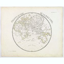
Oestliche Halbkugel.
A circular map of the eastern hemisphere, published in Steiler's Hand-Atlas in 1831. In German, each continent colored in outline.
Starting Bid: $36
BidAsk spread: $45 - $60
Maker / Publisher: REICHARD, C.G.Place & Date: Gotha, 1831
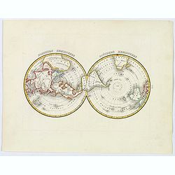
Northern Hemisphere / Southern Hemisphere.
This is an unusual and attractive 1835 map of the world on polar projections by the American mapmaker T. G. Bradford. It shows the world as seen from the North Pole and S...
Starting Bid: $52
BidAsk spread: $60 - $100
Maker / Publisher: BRADFORD, T.G.Place & Date: Boston, 1835
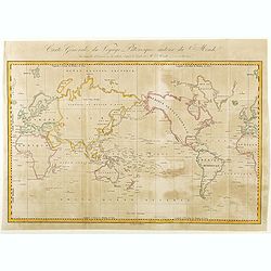
Carte Générale de Voyage Pittoresque Autour du Monde.
A map of the world centered on the Pacific Ocean. Engraved by Ambroise Tardieu.Jules Sébastien César Dumont d'Urville (1790 – 1842) was a French explorer, naval offic...
Starting Bid: $76
BidAsk spread: $100 - $125
Maker / Publisher: DUMONT D'URVILLE, J. (after)Place & Date: Paris, ca. 1840
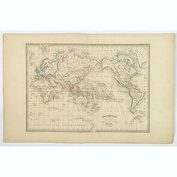
Mappemonde suivant la Projection de Mercator.
This map uses Mercator projection and shows the entire world. Major regions (North and South America, Europe, Asia, Africa, and Australia) are shaded in different origina...
- Highest Bid:
- $36 / ≈ €32.93
BidAsk spread: $45 - $65
Maker / Publisher: FREMIN / JACOBS.Place & Date: Paris, ca 1845
1 bid
Karta öfver Jord-Globen (World map)
An very rare double hemisphere world map. This is an heavenly updated version of his map of 1817 and is now dated 1848, Australia with new nomenclature and the old title ...
Starting Bid: $100
BidAsk spread: $120 - $250
Maker / Publisher: ÅKERLAND, EPlace & Date: A. Wiborgs förlag, Stockholm, ca. 1848
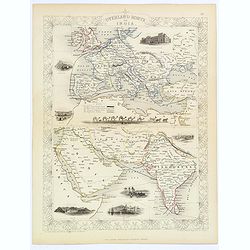
Overland Route to India.
Decorative steel engraved map of the Overland Route to India, surrounded 8 decorative vignettes.Taken from "The illustrated atlas and modern history of the world by ...
Starting Bid: $76
BidAsk spread: $85 - $135
Maker / Publisher: TALLIS, J.Place & Date: London, 1851
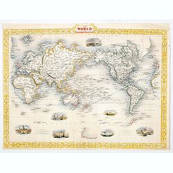
The World on Mercator's Projection.
Drawn & engraved by John Rapkin for "The Illustrated Atlas and Modern History of the World" by Montgomery Martin. Published London 1851 by The London Printi...
Starting Bid: $95
BidAsk spread: $120 - $180
Maker / Publisher: TALLIS, John.Place & Date: London, 1851
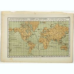
Kaart der Isodynamen.
One of the earliest thematic maps published in the Netherlands from "Atlas der natuurkundige aardrijkskunde. . .". prepared by Nicolaas Wilhelmus Posthumus. The...
Starting Bid: $16
BidAsk spread: $20 - $35
Maker / Publisher: POSTHUMUS, N.W.Place & Date: Amsterdam, C.L. Brinkman, 1883
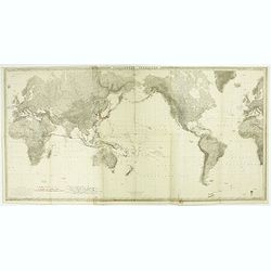
Planisphère terrestre.
A huge (2 meters) world map representing Asia and America in the center, Europe and Africa at left and right hand of the map. Published by the Service hydrographique in 1...
Starting Bid: $400
BidAsk spread: $480 - $800
Maker / Publisher: GERMAIN, A.Place & Date: Paris, Service hydrographique, 1902-1914
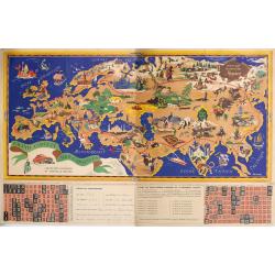
Offert par le chocolat Menier.
A large pictorial promotional map produced for the French chocolate company Menier in Paris in the late 1950s. The artist was J.B. Jannot (Jan-Loup). The map is essentia...
- Highest Bid:
- $130 / ≈ €118.92
BidAsk spread: $130 - $275
Maker / Publisher: MENIER CHOCOLATE COMPANY.Place & Date: Paris, ca 1958
1 bid