Browse Listings in Antique Maps > America
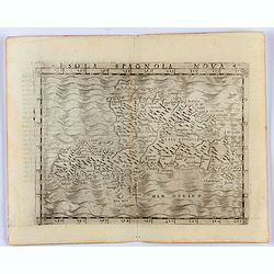
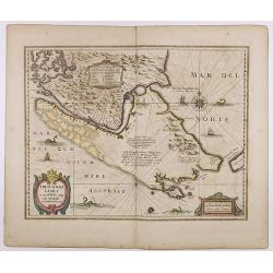
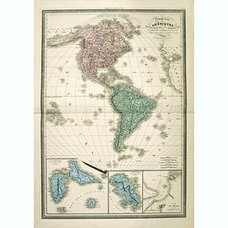
Isola Spagnola Nova.
Gastaldi's map of the island of Haiti and the Dominican republic.From Giacomo Gastaldi's Atlas of 1548 which has been called the most comprehensive atlas, produced betwee...
Starting Bid: $320
BidAsk spread: $390 - $600
Maker / Publisher: GASTALDI, G.Place & Date: Venice, 1548

Hispania Nova.
The rare Samuel Purchas' edition of the Mercator/Hondius Atlas Minor atlas map. This was the standard map of the area for a generation. The map shows an area correspondin...
Starting Bid: $50
BidAsk spread: $75 - $100
Maker / Publisher: HONDIUS, J. / PURCHAS, S.Place & Date: London, 1625
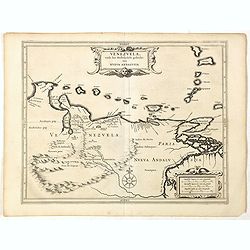
Venezuela, atque Occidentalis Pars Novæ Andalusiae.
Coastline of Venezuela with little interior development. Including Aruba, Bonaire, Curaçao, etc. Scarce map prepared by Hessel Gerritsz (1581-1632), former apprentice of...
Starting Bid: $320
BidAsk spread: $390 - $600
Maker / Publisher: LAET, DE J. / GERITSZ, H.Place & Date: Leiden, Elzevier, 1630
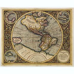
America sive India Nova.
This map was created by Michael Mercator, grandson of the great Gerard Mercator. It is the only map attributed to him. The map first appeared in 1595, one year after the ...
Starting Bid: $1750
BidAsk spread: $2000 - $3000
Maker / Publisher: MERCATOR, G. / HONDIUS, J.Place & Date: Amsterdam, 1630
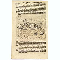
![[English attack Praia.]](/uploads/cache/39900-250x250.jpg)
[English attack Praia.]
Scarce print with German text sheet showing the English attack on Praia. On 16 November, 1585, during Francis Drake’s round-the-world voyage, his fleet anchored off San...
Starting Bid: $80
BidAsk spread: $100 - $150
Maker / Publisher: GOTTFRIED, J.L. / DE BRY.Place & Date: Frankfurt, M.Merian, 1633
![[Dutch attack the fortress of Praia.]](/uploads/cache/39901-250x250.jpg)
[Dutch attack the fortress of Praia.]
Scarce print with German text sheet showing the Dutch attack on Praia.On 27th June 1589, Simon de Cordes left Holland with five ships, bound for the Magellan Straits. On ...
Starting Bid: $40
BidAsk spread: $50 - $80
Maker / Publisher: GOTTFRIED, J.L. / DE BRY.Place & Date: Frankfurt, M.Merian, 1633
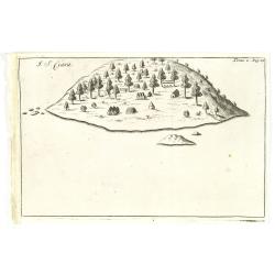
S. Jago.
Scarce print with German text sheet showing the Dutch at Santiago. The Dutch were invited to visit the harbour, about two miles along the coast. On arrival, they found it...
Starting Bid: $40
BidAsk spread: $50 - $100
Maker / Publisher: GOTTFRIED, J.L. / DE BRY.Place & Date: Frankfurt, M.Merian, 1633
![[Isle la Moche].](/uploads/cache/39909-250x250.jpg)
[Isle la Moche].
Scarce print with a German text sheet showing the Dutch fleet anchored off the Island of Mocha, near Concepción in Chile. The islanders sat on wooden stumps and watched ...
Starting Bid: $64
BidAsk spread: $80 - $100
Maker / Publisher: GOTTFRIED, J.L. / DE BRY.Place & Date: Frankfurt, M.Merian, 1633
![[Cavendish reaches Morro Moreno.]](/uploads/cache/39910-250x250.jpg)
[Cavendish reaches Morro Moreno.]
Scarce print with a German text sheet showing Cavendish’s fleet anchor at a place called Morro Moreno, on the coast of Chile. The Indians came down from the high cliffs...
Starting Bid: $40
BidAsk spread: $50 - $80
Maker / Publisher: GOTTFRIED, J.L. / DE BRY.Place & Date: Frankfurt, M.Merian, 1633
![[French seizure of Chiorera.]](/uploads/cache/39911-250x250.jpg)
[French seizure of Chiorera.]
Scarce print with a German text sheet showing the French torching and looting Chiorera. From de Bry's "Great American Voyages". Johann Theodor de Bry (1561-1623...
Starting Bid: $40
BidAsk spread: $50 - $80
Maker / Publisher: GOTTFRIED, J.L. / DE BRY.Place & Date: Frankfurt, M.Merian, 1633
![[Sir Walter Ralegh meets the King of Arromaia].](/uploads/cache/39916-250x250.jpg)
[Sir Walter Ralegh meets the King of Arromaia].
Scarce print with a German text sheet. During Ralegh’s voyage up the Orinoco in search of El Dorado, he met an old man who said he was the king of Arromaia. He claimed ...
Starting Bid: $72
BidAsk spread: $90 - $125
Maker / Publisher: GOTTFRIED, J.L. / DE BRY.Place & Date: Frankfurt, M.Merian, 1633
![[Black slaves escape punishment].](/uploads/cache/39920-250x250.jpg)
[Black slaves escape punishment].
Scarce print with a German text sheet. Many Black slaves, weary of ill treatment, managed to escape Spanish captivity and freely wandered the island, breaking into prison...
Starting Bid: $40
BidAsk spread: $50 - $80
Maker / Publisher: GOTTFRIED, J.L. / DE BRY.Place & Date: Frankfurt, M.Merian, 1633
![[Religious ritual on Hispaniola].](/uploads/cache/39921-250x250.jpg)
[Religious ritual on Hispaniola].
Scarce print with a German text sheet.On certain feast-days the Indian cacique, while beating a drum, led a procession of his people to the worship of their idol, which w...
Starting Bid: $40
BidAsk spread: $50 - $80
Maker / Publisher: GOTTFRIED, J.L. / DE BRY.Place & Date: Frankfurt, M.Merian, 1633
![[Captain Weert dines with the Chief].](/uploads/cache/39922-250x250.jpg)
[Captain Weert dines with the Chief].
Scarce print with a German text sheet. Captain Weert and the chief ate modestly on roast plantain, smoked fish and wine fermented from palm, bought by a local woman. Howe...
Starting Bid: $40
BidAsk spread: $50 - $80
Maker / Publisher: GOTTFRIED, J.L. / DE BRY.Place & Date: Frankfurt, M.Merian, 1633
Freti Magellanici ac novi Freti vulgo Le Maire. . .
A fine map of Tierra del Fuego. With an explanatory text of the passage by Barent Jansz. Potgieter who accompanied captain Sebald de Weert to the Straits in 1599/1600, be...
Starting Bid: $400
BidAsk spread: $500 - $750
Maker / Publisher: HONDIUS, H.Place & Date: Amsterdam, ca. 1633
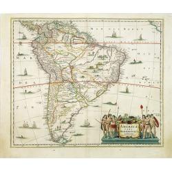
Americae pars meridionalis.
Decorated with several ships and sea monsters, and a cartouche flanked by engravings of six Indians, netted hammocks and South American fauna.
- Highest Bid:
- $350 / ≈ €320.18
BidAsk spread: $350 - $1000
Maker / Publisher: JANSSONIUS, J.Place & Date: Amsterdam, 1650
2 bids
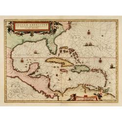
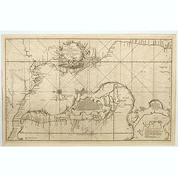
Insulae Americanae in oceano septentrionali..
Showing the Gulf of Mexico and the West Indian Islands, and the adjacent North and South American coastlines.The cartography is based on the rare Gerritz chart of 1631. T...
Starting Bid: $500
BidAsk spread: $600 - $1000
Maker / Publisher: JANSSONIUS, J.Place & Date: Amsterdam, 1660
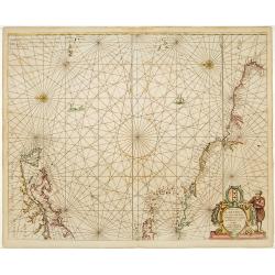
Pascaerte van Carybes, Nieu Neder landt, Brazil. . .
This progenitor chart covers the American shores of the Atlantic Ocean. This chart by Theunis Jacobsz. was most probably engraved close to his death in 1650 or shortly af...
Starting Bid: $800
BidAsk spread: $1000 - $2200
Maker / Publisher: JACOBSZ,Th.Place & Date: Amsterdam, 1653-1681
I. S. Clara.
Island "S. Clara" in Brazil just a few degrees north of the Tropic of Capricorn.From volume two of the French reissue of the account of early Dutch voyages. The...
Starting Bid: $25
BidAsk spread: $40 - $150
Maker / Publisher: DE RENNEVILLE, R.A.C.Place & Date: Amsterdam, E. Roger, 1703
Carte du gouvernement de l'Amerique.
A double-page sheet including a fine map of America, with California with indented northern coastline (130x92mm.) and New Mexico extending across most of western North Am...
Starting Bid: $75
BidAsk spread: $100 - $300
Maker / Publisher: CHATELAIN, H.Place & Date: Amsterdam, 1705
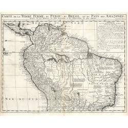
Carte de la Terre Ferme, du Perou, du Bresill, et du Pays des Amazones…
Starting Bid: $120
BidAsk spread: $150 - $300
Maker / Publisher: Chatelain, H.Place & Date: Amsterdam, 1719
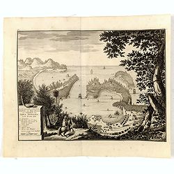
Haven van Aquapulco in ' Coninkryk van Nova Spagnien in de Zuyd Zee.
A finely engraved plan of the harbor, fort and village of Acapulco drawn from a hilltop vantage point looking out to sea. Several galleons are pictured approaching or anc...
Starting Bid: $200
BidAsk spread: $300 - $500
Maker / Publisher: VALENTIJN, F.Place & Date: Amsterdam, 1726
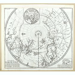
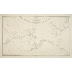
This Draught of the North Pole is to show all the Countries near and adjacent to it . . .
The polar map shows the latest discoveries and routes of numerous explorers during their attempts to find a Northwest and Northeast Passage, including James, Hudson, and ...
Starting Bid: $160
BidAsk spread: $200 - $300
Maker / Publisher: MOLL, H.Place & Date: London, ca. 1728
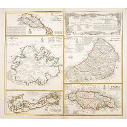
Dominia Anglorum in praecipuis Insulis Americae ut sunt Insula S. Christopheri, Antegoa, Iamaica, Barbados nec non Insula Bermudes vel Sommers . . .
Four maps of the islands of West Indies (St. Christoph "Delineatio Insulae St, Christophori alias I. Kitts", Antigua "Insula Antegoa", Barbados &q...
- Highest Bid:
- $250 / ≈ €228.70
BidAsk spread: $300 - $500
Maker / Publisher: HOMANN HEIRS.Place & Date: Nuremberg, 1740
1 bid
New & Correct Chart of the Pacific or South Sea, built by the best news from the Pilots. . .
A fine Spanish sea chart that is divided into three sections that cover the Central and South American Pacific coastline from Valparais in Chile to Acapulco in Mexico. No...
Starting Bid: $240
BidAsk spread: $300 - $450
Maker / Publisher: MARIN, Antonio.Place & Date: Madrid, ca 1748
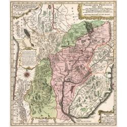
Paraquariae Provinciae Soc. Iesu
Paraquariae Provinciae Soc. Iesu cum Adjacentibus Novissima Descriptio Post iterates peregrinations, et plures observations Patrum Missionariorum ejusdem Soc. tum hujus P...
Starting Bid: $300
BidAsk spread: $300 - $500
Maker / Publisher: Seutter, M.Place & Date: Augsburg, 1750
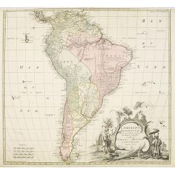
L'amerique meridionale dressee sur les memoires le plus recens. . .
Rare and decorative map of South America with good detail and interesting notations concerning the explorations of the interior. With in the lower right corner a title ca...
Starting Bid: $250
BidAsk spread: $300 - $500
Maker / Publisher: COVENS, J. / MORTIER, C.Place & Date: Amsterdam, 1757
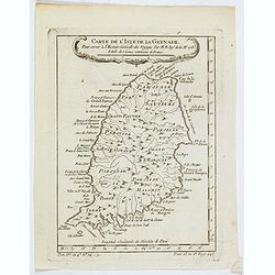
Carte de L'Isle de la Grenade. . .
A detailed map of the Caribbean Island of Grenada, showing a resonable amount detail for the time period. This include the location of parishes, rivers, mountains, bays, ...
Starting Bid: $28
BidAsk spread: $35 - $50
Maker / Publisher: BELLIN, J.N.Place & Date: Paris, 1758
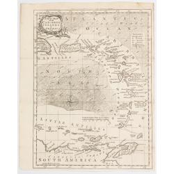
A New Map of the Caribee Islands in America 1761.
Thomas Kitchin's map of the eastern Caribbean produced for Smollet's Continuation of the History of Englnd. The map extends from Santa Domingo in the north, then swings i...
Starting Bid: $45
BidAsk spread: $55 - $100
Maker / Publisher: KITCHIN, Thos.Place & Date: London, 1761
![[No title] Les Isles Vierges. . .](/uploads/cache/46289-250x250.jpg)
[No title] Les Isles Vierges. . .
A nice French map of the Virgin Islands (Christopher Columbus named the islands after Saint Ursula and the 11,000 Virgins), an archipelago and part of the Greater Antille...
Starting Bid: $48
BidAsk spread: $60 - $100
Maker / Publisher: BONNE, Rigobert.Place & Date: Paris, ca 1770
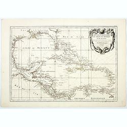
Carte Geo-Hydrographique du Golfe du Mexique et de ses Isles. . .
A lovely map illustrating the Gulf of Mexico and the West Indies, with a delightfully stylish rococo title cartouche. From the Florida Panhandle to the northern tip of So...
Starting Bid: $96
BidAsk spread: $120 - $200
Maker / Publisher: RIZZI-ZANNONI,G. A. / LATTRÉPlace & Date: Paris, 1770
![[Lot of 4 maps] of South America. Amérique Meridionale](/uploads/cache/19999-(2)-250x250.jpg)
[Lot of 4 maps] of South America. Amérique Meridionale
Gilles Robert de Vaugondy (!686-1766) and son Didier (1723-86), Paris geographers and publishers. Gilles succeedded Pierre Moulart Sanson in 1730. ' Atlas Portatif', 1748...
Starting Bid: $200
BidAsk spread: $220 - $480
Maker / Publisher: Robert de Vaugondy, G. / D.Place & Date: Paris, 1776
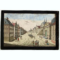
Prospect des Haupt Plazes der Untern Stadt zu Quebec.
A so-called optical print showing a decorative imaginary town view of Québec, with a street view with soldiers marching and pedestrians, an idealized view depicting Qué...
Starting Bid: $280
BidAsk spread: $340 - $500
Maker / Publisher: ACADEMIEPlace & Date: Augsburg, ca.1780
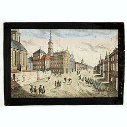
Prospect der Strasse gegen der Kirche der Recolecten in der obern Stadt zu Quebec. Vuë de la Rue des Recolets dans la haute Ville de Quebec.
A so-called optical print showing a decorative imaginary town view of Québec, with a street view with soldiers marching and pedestrians, an idealized view depicting Qué...
Starting Bid: $280
BidAsk spread: $340 - $450
Maker / Publisher: ACADEMIEPlace & Date: Augsburg, ca. 1780
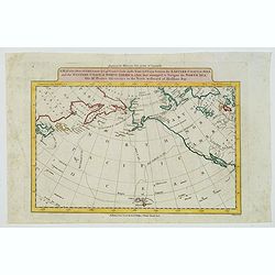
A Map of the Discoveries made by Capt. Cook & Clerke in the Years 1778 & 1779 between the Eastern Coast of Asia and the Western Coast of America. . .
This map charts the tracks of the explorations of Captain James Cook in 1778 & 1779, including his ill fated stop in Hawaii, (here called the Sandwich Islands). The ...
Starting Bid: $64
BidAsk spread: $80 - $125
Maker / Publisher: WILKIE, G & T.Place & Date: London, 1785
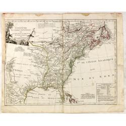
ETATS-UNIS DE L'AMÉRIQUE SEPTENTRIONALE Avec LES ISLES ROYALE, DE TERRE NEUVE, DE S.T JEAN, L'ACADIE, &c. 1785. Supplement a l'Atlas de M. Robert de Vaugondy a Paris Ches Boudet Ingenieur du Roi.
A map of the eastern United States with "Supplément à l'atlas de M Robert de Vaugondy à Paris chez Boudet Imprimeur du Roi", in place of the attribution to D...
- Highest Bid:
- $800 / ≈ €731.83
BidAsk spread: $1000 - $1750
Maker / Publisher: BOUDET. / DE VAUGONDY, R.Place & Date: Paris, 1785
1 bid
Karte von den N.W. Amerikanische und N.O.E. Asia. . .
German edition of Cook's explorations along the NW Coast of America and NE Coast of Asia, based upon the original work by Lieutenant Henry Roberts.A detailed large-scale ...
Starting Bid: $240
BidAsk spread: $290 - $400
Maker / Publisher: SCHRAEMBL, F.A.Place & Date: Vienna, 1788
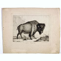
Bison Iubatus.
Etching of a bison by Leendert Brasser (1727 - 1793) after a painting of the Dutch artist Gerrit van den Heuvel.An early portrait of a bison, etched by Leendert Brasser (...
Starting Bid: $400
BidAsk spread: $480 - $750
Maker / Publisher: BRASSIER, LPlace & Date: Rotterdam, 1766-1793
A New Map of the Whole Continent of America, Divided into North and South and West Indies...
This significant map of the Americas was originally published by Sayer & Bennett and has been updated and reissued by Laurie & Whittle. Initially released on four...
Starting Bid: $800
BidAsk spread: $1000 - $1800
Maker / Publisher: Laurie, R. and Whittle, J.Place & Date: London, 1794
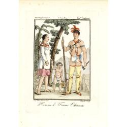
Homme & Femme Ottawas.
Hand-colored mezzotint of Native Americans engraved by Félix Mixelle and Lachaussée Jeune after Jacques Grasset de Saint-Sauveur.As an etcher, drawer and writer, Grasse...
Starting Bid: $32
BidAsk spread: $40 - $75
Maker / Publisher: GRASSET DE SAINT SAUVEUR,J.Place & Date: Paris,1801-1806
Map of the Island of St. Vincent. . .
A map by John Stockdale of the Island of St-Vincent that was originally published in 1794 in Bryan Edwards’ The History Civil & Commercial of the British Colonies�...
Starting Bid: $48
BidAsk spread: $60 - $100
Maker / Publisher: EDWARDS, Bryan.Place & Date: London, 1818
N. America.
I am assuming this map of North] America is by Joseph Mawman (fl. 1797-1827) as the possible identification at the base of the map is indistinct. Joseph Mawman was an Eng...
Starting Bid: $1
BidAsk spread: $1 - $100
Maker / Publisher: MAWMAN, J.Place & Date: London, ca 1819
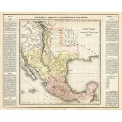
Geographical, Statistical, & Historical Map of Mexico
A superb map of depicting Mexico prior to the succession of Texas and the loss of their northern territories to the United States after the Mexica-American war.The map pr...
- Highest Bid:
- $400 / ≈ €365.91
BidAsk spread: $400 - $800
Maker / Publisher: Carey and LeaPlace & Date: Philadelphia 1822
2 bids
Amérique septentrionale.
A fine map of North America published by the well-known Paris publisher of maps, globes and atlases C.F. Delamarche.
Starting Bid: $45
BidAsk spread: $60 - $110
Maker / Publisher: DELAMARCHE, F.Place & Date: Paris, 1824
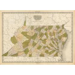
Virginia Maryland and Delaware
One of the finest early 19th century maps of Virginia (West Virginia) Maryland, and Delaware made at the end of an era of map making that utilized steel and copper engrav...
Starting Bid: $500
BidAsk spread: $600 - $1200
Maker / Publisher: Henry Schenk TannerPlace & Date: Philadelphia, 1825
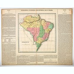
Geographical, Statistical, and Historical Map of Brazil.
A rich full color example of this interesting map of Brazil, from Carey & Lea's Atlas. It is one of the first separate maps of the newly independent Brazil. The map i...
Starting Bid: $52
BidAsk spread: $65 - $95
Maker / Publisher: CAREY & LEA.Place & Date: Philadelphia, 1825
![[Araucani chief and his entourage from Chile ].](/uploads/cache/27302-250x250.jpg)
[Araucani chief and his entourage from Chile ].
Aquatint depicting an Araucani chief and his entourage. They were known as the toughest indigenous people of South America. The Araucans are Amerindian tribes habiting th...
Starting Bid: $15
BidAsk spread: $25 - $85
Maker / Publisher: FERRARIO, G.Place & Date: Milan, 1827
![[ Santiago inhabitants in their local dress. ]](/uploads/cache/27294-250x250.jpg)
[ Santiago inhabitants in their local dress. ]
Aquatint depicting inhabitants of Santiago in local dress.Engraved by Gallina.From Giulio Ferrario's work Le Costume Ancien et Moderne ou Histoire du gouvernement, de la ...
Starting Bid: $15
BidAsk spread: $25 - $50
Maker / Publisher: FERRARIO, G.Place & Date: Milan, 1827
![[Jesuitical Indians at work at their 'Reducciones' ]](/uploads/cache/27300-250x250.jpg)
[Jesuitical Indians at work at their 'Reducciones' ]
Aquatint depicting Jesuitical Indians in Paraguay. The Jesuit Missions or "Reducciones" functioned like small independent "republics" and lived in com...
Starting Bid: $15
BidAsk spread: $25 - $80
Maker / Publisher: FERRARIO, G.Place & Date: Milan, 1827
![[ Chilean indians playing ciueca ].](/uploads/cache/27299-250x250.jpg)
[ Chilean indians playing ciueca ].
Aquatint depicting Chilean indians playing "ciueca", a native hockey-like game. Engraved by Fumagalli.From Giulio Ferrario's work Le Costume Ancien et Moderne ...
Starting Bid: $15
BidAsk spread: $25 - $75
Maker / Publisher: FERRARIO, G.Place & Date: Milan, 1827
![[ Indians playing Queciu (top) and Porotos (bottom) ].](/uploads/cache/27298-250x250.jpg)
[ Indians playing Queciu (top) and Porotos (bottom) ].
Aquatint depicting Indians playing Queciu (top) and Porotos (bottom). Engraved by Fumagalli.From Giulio Ferrario's work Le Costume Ancien et Moderne ou Histoire du gouve...
Starting Bid: $15
BidAsk spread: $25 - $50
Maker / Publisher: FERRARIO, G.Place & Date: Milan, 1827
![[ Hunting scene of Botocudos family, Rio Grande, Brazil ].](/uploads/cache/27297-250x250.jpg)
[ Hunting scene of Botocudos family, Rio Grande, Brazil ].
Aquatint depicting a hunting scene of a native Botocudos family, Rio Grande, Brazil.Engraved by Gallina.From Giulio Ferrario's work Le Costume Ancien et Moderne ou Histoi...
Starting Bid: $15
BidAsk spread: $25 - $60
Maker / Publisher: FERRARIO, G.Place & Date: Milan, 1827
![[ Charruas Indians from Paraguay ].](/uploads/cache/27296-250x250.jpg)
[ Charruas Indians from Paraguay ].
Aquatint depicting the Charruas Indians cooking. The charruas Indians were the first inhabitants who hunted and fished in the area now known as Uruguay. They have probabl...
Starting Bid: $15
BidAsk spread: $25 - $60
Maker / Publisher: FERRARIO, G.Place & Date: Milan, 1827
![[ Guayanas inhabitants Paraguay ].](/uploads/cache/27295-250x250.jpg)
[ Guayanas inhabitants Paraguay ].
Aquatint depicting some relexing Guayanas Indians of Paraguay, who occupy the rivers flowing to the right bank of the Parana.The Charruas Indians were the first inhabitan...
Starting Bid: $15
BidAsk spread: $25 - $50
Maker / Publisher: FERRARIO, G.Place & Date: Milan, 1827
![[ Fortresss of Cannar in Quito Peru ].](/uploads/cache/27293-250x250.jpg)
[ Fortresss of Cannar in Quito Peru ].
Aquatint depicting the fortress of Cannar in Quito Peru inspired by a print from atlas by Alexander Von Humboldt.Engraved by E. F.From Giulio Ferrario's work Le Costume A...
Starting Bid: $15
BidAsk spread: $25 - $80
Maker / Publisher: FERRARIO, G.Place & Date: Milan, 1827
![[ The circular fortress of Cannar, Peru. ]](/uploads/cache/27292-250x250.jpg)
[ The circular fortress of Cannar, Peru. ]
Aquatint depicting the circular fortress of Cannar, Peru.Engraved by Fumagalli.From Giulio Ferrario's work Le Costume Ancien et Moderne ou Histoire du gouvernement, de la...
Starting Bid: $15
BidAsk spread: $25 - $80
Maker / Publisher: FERRARIO, G.Place & Date: Milan, 1827
![[Spanish Sheppard's in Paraguay ].](/uploads/cache/27290-250x250.jpg)
[Spanish Sheppard's in Paraguay ].
Aquatint depicting Spanish Sheppard's in Paraguay.Engraved by Gallina.From Giulio Ferrario's work Le Costume Ancien et Moderne ou Histoire du gouvernement, de la milice, ...
Starting Bid: $15
BidAsk spread: $25 - $50
Maker / Publisher: FERRARIO, G.Place & Date: Milan, 1827
![[The Callo Palace.]](/uploads/cache/27289-250x250.jpg)
[The Callo Palace.]
Aquatint depicting upper portion of print an Inca Palace near Cannar in the province of Quito in Peru. Bottom portion a plan of the palace (70 x 160).Engraved by Fumagall...
Starting Bid: $15
BidAsk spread: $25 - $80
Maker / Publisher: FERRARIO, G.Place & Date: Milan, 1827
![[The Callo Palace ].](/uploads/cache/27288-250x250.jpg)
[The Callo Palace ].
Aquatint depicting Peruvian Inca Palace called Callo.Engraved by Fumagalli.From Giulio Ferrario's work Le Costume Ancien et Moderne ou Histoire du gouvernement, de la mil...
Starting Bid: $15
BidAsk spread: $25 - $80
Maker / Publisher: FERRARIO, G.Place & Date: Milan, 1827
![[Yacanacus inhabitants of Tierra del Fuego ].](/uploads/cache/27304-250x250.jpg)
[Yacanacus inhabitants of Tierra del Fuego ].
Aquatint depicting Yacanacus natives of Tierra del Fuego. Engraved by Gallina.From Giulio Ferrario's work Le Costume Ancien et Moderne ou Histoire du gouvernement, de la...
Starting Bid: $15
BidAsk spread: $25 - $100
Maker / Publisher: FERRARIO, G.Place & Date: Milan, 1827
![[ Mexican Temazcalli or vapor baths ].](/uploads/cache/27738-250x250.jpg)
[ Mexican Temazcalli or vapor baths ].
Aquatint depicting a Mexican Temazcalli by Fumagalli. As a great preventive against disease the Mexicans used the bath frequently—especially the Temazcalli, or vapor-b...
Starting Bid: $15
BidAsk spread: $25 - $100
Maker / Publisher: FERRARIO, G.Place & Date: Milan, 1827
![[ A Teocalli in Mexico - Aztec Temple ].](/uploads/cache/27580-250x250.jpg)
[ A Teocalli in Mexico - Aztec Temple ].
Aquatint depicting a Aztec Temple engraved by Fumagalli. From Giulio Ferrario's work Le Costume Ancien et Moderne ou Histoire du gouvernement, de la milice, de la relig...
Starting Bid: $15
BidAsk spread: $25 - $150
Maker / Publisher: FERRARIO, G.Place & Date: Milan, 1827
![[ Pampas Indians near Buenos Aires in Argentina ].](/uploads/cache/27322-250x250.jpg)
[ Pampas Indians near Buenos Aires in Argentina ].
Aquatint depicting the Pampas Indians in front of a local shop near Buenos Aires. Engraved by Bonatti.From Giulio Ferrario's work Le Costume Ancien et Moderne ou Histoir...
Starting Bid: $15
BidAsk spread: $25 - $100
Maker / Publisher: FERRARIO, G.Place & Date: Milan, 1827
![[Botocudos tribe of the Rio Grande, Paraguay ].](/uploads/cache/27320-250x250.jpg)
[Botocudos tribe of the Rio Grande, Paraguay ].
Aquatint depicts the Botocudos tribe of the Rio Grande in Paraguay.Botocudo (from Portuguese for botoque, a plug, in allusion, to the wooden disks or plugs worn in their ...
Starting Bid: $64
BidAsk spread: $80 - $120
Maker / Publisher: FERRARIO, G.Place & Date: Milan, 1827
![[Botocudos tribe artifacts ].](/uploads/cache/27318-250x250.jpg)
[Botocudos tribe artifacts ].
Aquatint depicting artifacts from the Botocudos tribel.Engraved by Gallina.From Giulio Ferrario's work Le Costume Ancien et Moderne ou Histoire du gouvernement, de la mil...
Starting Bid: $24
BidAsk spread: $30 - $60
Maker / Publisher: FERRARIO, G.Place & Date: Milan, 1827
![[Patacho Tribesmen of the Rio do Prado. ]](/uploads/cache/27317-250x250.jpg)
[Patacho Tribesmen of the Rio do Prado. ]
A native Patacho Tribesman is about to cut open a piece of fruit (melon?) with a hatchet while another holds a bow and arrows or spears while looking on. Behind them are ...
Starting Bid: $15
BidAsk spread: $25 - $60
Maker / Publisher: FERRARIO, G.Place & Date: Milan, 1827
![[Birds from Brazil ].](/uploads/cache/27307-250x250.jpg)
[Birds from Brazil ].
Aquatint depicting 6 different species of birds from Brazil. Engraved by Raineri.From Giulio Ferrario's work Le Costume Ancien et Moderne ou Histoire du gouvernement, de ...
Starting Bid: $15
BidAsk spread: $25 - $75
Maker / Publisher: FERRARIO, G.Place & Date: Milan, 1827
![[Indians of Patagonia, Chile, greeting a European traveller, probably Louis Antoine de Bougainville. ]](/uploads/cache/27303-250x250.jpg)
[Indians of Patagonia, Chile, greeting a European traveller, probably Louis Antoine de Bougainville. ]
Aquatint depicting Indians of Patagonia, Chile, greeting a European traveller, probably Louis Antoine de Bougainville. Comte de Bougainville was a French admiral and expl...
Starting Bid: $32
BidAsk spread: $40 - $75
Maker / Publisher: FERRARIO, G.Place & Date: Milan, 1827
![[Coroados artifacts from Brazil ].](/uploads/cache/27309-250x250.jpg)
[Coroados artifacts from Brazil ].
Aquatint depicting artifacts used by the Coroados tribe of Brazil. Engraved by Fumagalli.From Giulio Ferrario's work Le Costume Ancien et Moderne ou Histoire du gouverne...
Starting Bid: $15
BidAsk spread: $25 - $80
Maker / Publisher: FERRARIO, G.Place & Date: Milan, 1827
![[Camacan indians in Brazil ].](/uploads/cache/27312-250x250.jpg)
[Camacan indians in Brazil ].
Aquatint depicting the Camacan indians in the Amazonian forest. Engraved by Fumagalli.From Giulio Ferrario's work Le Costume Ancien et Moderne ou Histoire du gouverneme...
Starting Bid: $15
BidAsk spread: $25 - $70
Maker / Publisher: FERRARIO, G.Place & Date: Milan, 1827
![[Camacani Indian artifacts ].](/uploads/cache/27316-250x250.jpg)
[Camacani Indian artifacts ].
Aquatint depicting Camacani Indian artifacts. Engraved by Gallina.From Giulio Ferrario's work Le Costume Ancien et Moderne ou Histoire du gouvernement, de la milice, de ...
Starting Bid: $15
BidAsk spread: $25 - $75
Maker / Publisher: FERRARIO, G.Place & Date: Milan, 1827
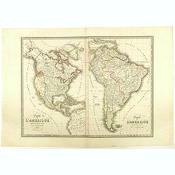
Nouvelle Carte des Amériques Septentrionale et Meridionale avec les Plans des Possessions Françaises en ces Pays, Rédigée et presentée à l'Académie des Sciences. . .
Large, skillfully engraved, and quite scarce map of North and South America, with insets at bottom of Guadeloupe, Martinique, and Plan de Cayenne. In California, the Sier...
Starting Bid: $240
BidAsk spread: $290 - $450
Maker / Publisher: BERTHEPlace & Date: Paris, Garnier Fréres, 1832
Carte de l'Amerique Septentrionale . . . / Carte de l'Amerique Méridionale . ..
Two maps of America on one sheet, by Nicolas Maire, a French geographer and published by Langlumé et Peltier.
Starting Bid: $96
BidAsk spread: $120 - $250
Maker / Publisher: MAIRE, N.Place & Date: Paris, 1834
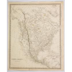
North America.
A detailed map of North America, published by Chapman & Hall in London for the S.D.U.K. TX is seen as a republic.Map extent is from the Arctic Circle (Russian) Alaska...
Starting Bid: $45
BidAsk spread: $55 - $100
Maker / Publisher: SOCIETY FOR THE DIFUSSION OF USEFUL KNOWLEDGE.Place & Date: London ca 1843
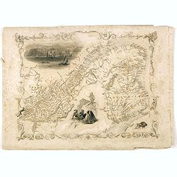
East Canada and New Brunswick.
This is John Tallis’ map of East Canada or what is now Quebec and New Brunswick. Includes Montreal, Quebec City, and the St. Lawrence River valley. Features five vignet...
Starting Bid: $40
BidAsk spread: $50 - $75
Maker / Publisher: TALLIS, J.Place & Date: London, 1851
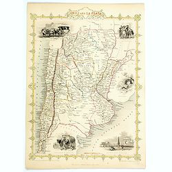
Chili and La Plata.
A nice decorative and detailed map of the region, depicting mountains, rivers, towns, islands, etc, imaginatively adorned with lovely small vignettes of a 'Travelling Pos...
Starting Bid: $28
BidAsk spread: $35 - $75
Maker / Publisher: TALLIS, John.Place & Date: London, 1851
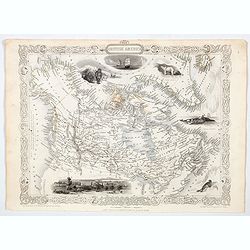
British America.
A decorative and useful map of modern day Canada, when it was still under British rule in the mid nineteenth century. The map is uplifted by the addition of five delightf...
Starting Bid: $75
BidAsk spread: $95 - $150
Maker / Publisher: TALLIS, John.Place & Date: London, 1851
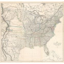
United States of North America (Eastern & Central)
This is a scarce six sheet map of the United States just prior to the Civil War and in this midst of Westward Expansion. The map made by Theodore Ettling and published by...
Starting Bid: $360
BidAsk spread: $400 - $800
Maker / Publisher: Ettling, TPlace & Date: London, 1859
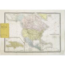
Carte de L'Amérique du Nord. . .
Detailed map of Nord America and Central America giving good detail along the east coast and the Lakes. Including San Francisco, Monterey, etc.With inset map of Dominican...
Starting Bid: $100
BidAsk spread: $125 - $250
Maker / Publisher: BÉRTHE, L.Place & Date: Paris, 1870
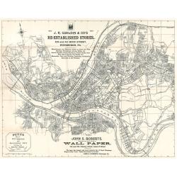
Reed's Map of Pittsburgh and Allegheny City
This is a rare map of Pittsburgh, Pennsylvania, crafted in 1891 by Baird Reed and subsequently published in 1892. The map includes two advertisements – one at the top f...
Starting Bid: $150
BidAsk spread: $150 - $300
Maker / Publisher: Reed, B.Place & Date: Pittsburgh, 1891